Act for enclosing the lands in the Parish of Beckley 28
May 1827
A copy of the Act is held at the Centre for Oxfordshire Studies in Cowley
Note that Studley was then the part of the village in Buckinghamshire with the border coinciding with the lane to Gardener’s Barn and Horton was the Oxfordshire part.
Extract:
Horton and Oxford Road One other Public Carriage Road and Highway of width 33 feet from the King’s Arms, Bicester Road to SE corner of Chapel Close, to Beckley. (Chapel Close must the field in Church Lane where a chapel once stood, although the present church was not built until 1868. This indicates that there was once a chapel on the site.)
The Bicester Road. One other Public Carriage Road and Highway of width 33 feet leaving the said Horton & Oxford Road at the south east corner of Chapel Close and proceeding in a westerly direction nearly in its present track by the pound to a cottage in the occupation of John White on Lower Green, thence in a northerly direction over the said Green into the Little Marsh and then continuing in a northern direction over the same to the commencement of a road set out under the Otmoor enclosure. (This describes what is now Ragnall’s Lane. The pound used to be at the start of what is now Ragnall’s Lane next to Ragnall’s House. John White probably lived in what is now Ragnall’s House. Note: there is no mention of Ragnall in any old document or archives and the origin remains a mystery. )
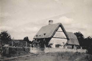
Ragnall’s House as a cottage circa 1930
The Brill Road One other Public Carriage Road and Highway of width 33 feet leading out of the last described road and commencing at the west end of Upper Green near the premises of Abraham Hillesden and proceeding in its present track until it enters the township of Studley in Buckinghamshire. (This is now known as Brill Road. Abraham Hillesden probably lived in the thatched cottage once known as Corner Cottage at the junction with Oakley Road and Horton Hill)
The Thame Road one other Public Carriage
Road and Highway of a width of 33 feet leading out of the last described road
at the commencement thereof and proceeding in a south east direction over the
Upper Green and Horton and Carbridge Commons to the parish of Boarstall at Poor
Folks Pasture Oak.
The Lower Green Road One other Private Carriage and Occupation Road and Public Highway of a width of 30 feet leading out of the Bicester Public Road and proceeding along the west side of Horton Lower Farm into Holland’s Field. (This is the road from Church Lane to West Hill Farm)
Mills Lane Road One other Private Carriage
and Occupation Road and Public Highway of a width of 30 feet leading out of
Bicester Public Road at the cottage in the occupation of William Haynes and
proceeding along Mills Lane to a house and ancient enclosure belonging to the
Earl of Abingdon with occupancy of Edward Crick.
(This is now Mill Lane, it was probably named after Thomas Mills who lived in the Lane and had land in the village (see 1641 map). William Haynes probably lived in the Thatched Cottage that was once the village shop.)
The Stanton Wood Road One other Private Carriage and Occupation Road and Public Highway of a width of 20 feet leading out of Horton and Oxford Public Road and proceeding along Horton Common to the gate in the Parish of Stanton St John. (This could be the public footpath that goes from opposite the entrance to Beckely Park past the gas sub-station)
Other minor roads and footpaths
Lower Beckley
Park Road to Beckley Park
The Stanton Footway 4 feet wide from the Beckley
Oxford Road
Horton Noke Footway
Horton Beckley Footway
Horton Islip Footway
The above are not described as they led across then un-enclosed land. However footpaths remain to Beckley, Noke etc
Horton to Bicester Footway 4 feet wide
leading out of Horton at the homestead of Samuel and Mary Blake and proceeding
in a north westerly direction into and across the Bicester Public Road over the
Nash Field until it enters Studley in Buckinghamshire at the stile in Otmoor
Furlong near Cuckoo Pen.
Each page is signed by Thomas Barford
The Brill Footway. 4feet leading out of the
village of Horton between two small old enclosures belonging to the Earl of
Abingdon in the occupation of Thomas Budd and proceeding in or near its present
track over the Mill Field and past the windmill until it enters Studley in
Buckinghamshire.
The Oakley Footway 4 feet out of the Thame
Public Road and proceeding in or near the present track across Horton and
Carbridge Commons to a stile in the boundary fence in the parish of Boarstall.
Studley and Stanton Footway … out of the
Thame Public Road at the bridge or tunnel over the same and proceeding in a
south westerly direction over Carbridge Common into the Stanton St John Public
Road opposite to a gate there in the parish of Oakley.
Horton and Stanton Footway … Horton and
Oxford Public road two yards west of the Bridge over the public drain and
proceeding in a south direction to a stile in the boundary fence of the parish
of Stanton St John.
Horton Common Drain one public drain width of seven feet commencing at the pond on Horton Common and proceeding in a north westerly direction over Vent Field and Holland Field into the drain on the south side of Otmoor.
And I do hearby award that the grass and herbage arising on
the said roads which are not within or leading over any attachment or allotment
shall ever belong to and be the sole right of the proprietors of the lands and
grounds within the said parish of Beckley next adjoining the said roads
respectively on either side thereof as far as the crown of the road.
As well and the big landowners – The Earl of Abingdon and the Croke family, the act also mentions grants to Elizabeth Bulford, widow, and Samuel Jacobs in 1770 and 1774.
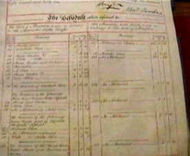
Schedule of landowners and taxes.