The village of Horton is one of the seven towns of Otmoor, and Studley, with its Priory, only became attached to it later. Both are in Bullingdon Hundred that included Stanton St John, Stowood, Beckley and villages to the west plus an unconnected area of Merton, Ambrosden and Piddington. Islip, Noke, Oddington and Charlton were in the Ploughley Hundred. Hundreds were the main administrative areas until the 19th century and have since been replaced by District Councils. The village of Horton cum Studley was once partly in Oxfordshire and partly in Buckinghamshire until 1882. The enclosure act of 1827 puts the Oxfordshire part as Horton and Studley Bucks over the border. The enclosure act of the parish of Beckley did not include Studley. The county border was then nearer the village and followed the lane from Brill Road to Gardener's Barn.
T
An earlier small settlement known as Ash or Asham (Atunash - at the ash tree) existed at one time in the Buckinghamshire part. but this has entirely disappeared. Horton and Studley were originally in Beckley Parish. Following the 1881 census the acreages were recorded with Beckley 3,620 acres, Horton cum Studley 1,287 acres and Studley (Bucks), 952 acres. (Kelly’s Dir. Oxon. 1920). In 1844 Studley Bucks was transferred to Oxfordshire. This included part of Whitecross Green woods and the hamlet of Whitecross Green.
The boundaries were revised in 1932 when 2,194 acres of Beckley were transferred to Fencott & Murcott.
The county border prior to 1882 was the stream that went from near Studley Farm House down onto Otmoor. The stream still exists mainly as a ditch crossed by a single plank when crossed from Mill Lane.
There are signs of Roman occupation on top of the hill near the old county boundary where fragments of Roman tiles can be found while a Roman lamp with five coins from the third century have been found by visitors with metal detectors about 100 yards from Gardener’s Barn house. The lamp and coins are believed to be with the British Museum. The Otmoor area had a number of Roman settlements with the Temple at Woodeaton and significant buildings in the Noke - Islip area. Roman pottery was made near Noke and there were probably other settlements yet to be discovered. A Roman round crossed Otmoor from the south to the town of Alchester near Bicester.

Fragment of a Roman almost 30mm thick found at the site of the Horton windmill. This is the type of tile used in substantial buildings and was thrown up by badgers from their set.
There were also Saxon settlements with a village at Woodperry near the house, and Asham may also have originally been a Saxon settlement. The name of Beckley is Saxon for lea of Becca or beck.
At the time of the Norman Conquest, Horton and Ashe were probably small settlements surrounded by forest to the south, east and north and Otmoor to the west. It is probable that in Roman times, Otmoor was much drier as they built their road from Dorchester to Alchester across the moor. It has been suggested that the water level rose after an earthquake in 1666. This seems a little unlikely as there is no sign of any occupation of the area and the villages and lanes were established before that date.
The name Otmoor is supposed to be derived from Otta’s Moor but no documentary evidence of this can be found. It is probable that Otmoor was a wet area before the Norman Conquest otherwise it is unlikely to have been given the pre-conquest name of Otta’s Moor.
The first record of Otmoor by name appears in an undated charter drawn up between 1006 and 1011 by which King Æthelred II granted to a Dane called Toti five mansi at Hortun and one at Beccalege (Horton and Beckley?). This was preserved in the Red Book of Thornley. The bounds of the lands are described as: " ... up of there ealden ea in to ottanmere. Of ottanmere thuyrsover bugenroda. of bugeroda into maer mer. of mearmere on merthorn .. "
Bugenroda may be the Roman road and Maerthorn or Maermere may have been Marlake. The lands were probably what is now Horton cum Studley, Beckley and Whirtecross Green, west to the Roman road. This is also the first mention of Horton or Hortun as a village.
The Roman occupation goes back to at least AD95 following dendrochronological examination of piles at a crossing point on the river Ray. In the Roman period up to AD410 bronze and Iron metal work would have been carried out and pottery made locally. Maybe Tile Close, named on the 1641 map, may have been the area where tiles were made. From the Roman tiles found it is likely that there were substantial Roman period buildings on the high ground while subsistence farming took place on the fertile area of Horton. Fresh water shellfish were certainly on their menu as many shells can be found in the area.
|
|
|
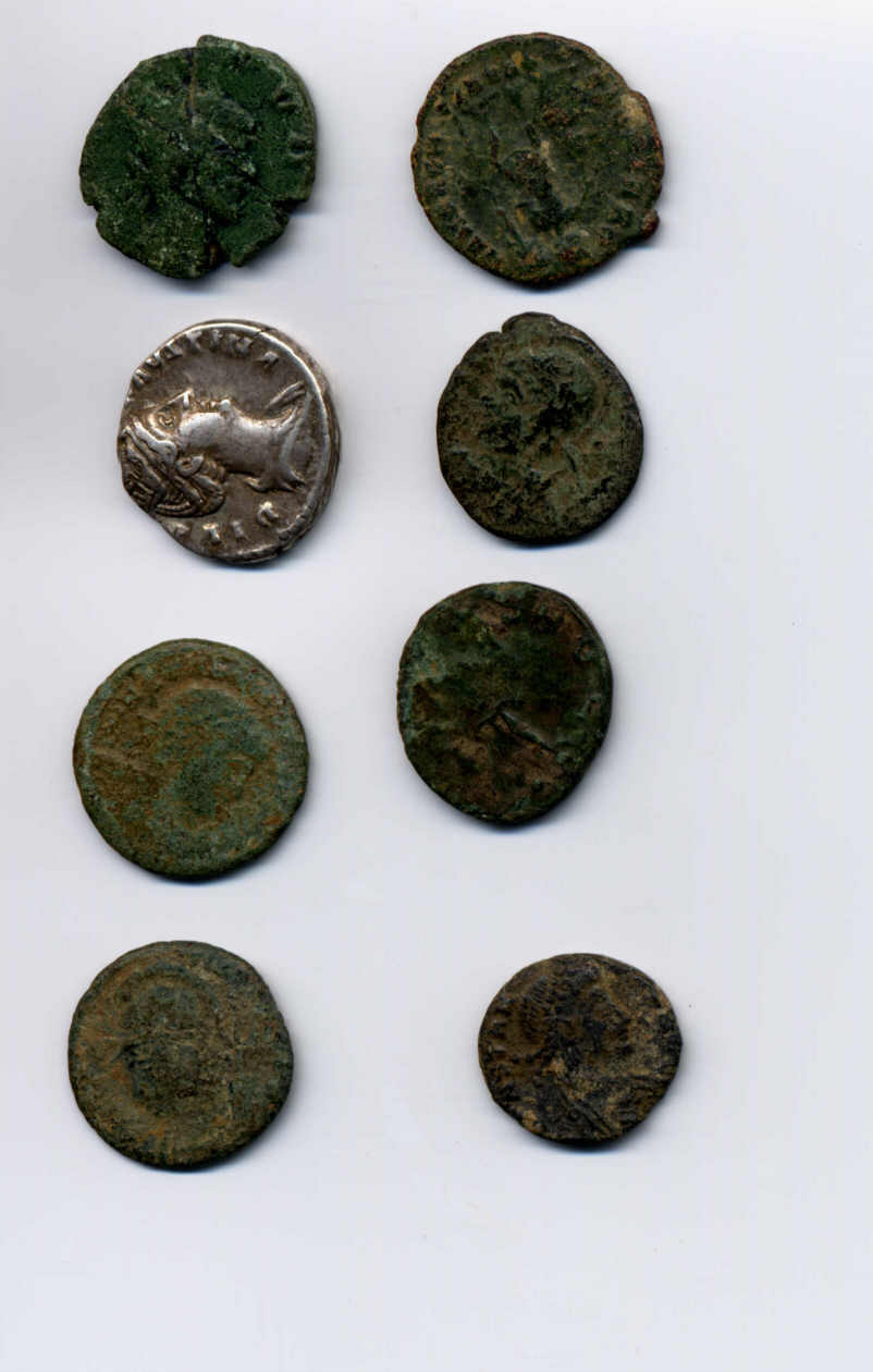
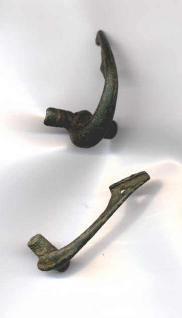
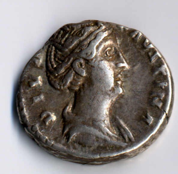
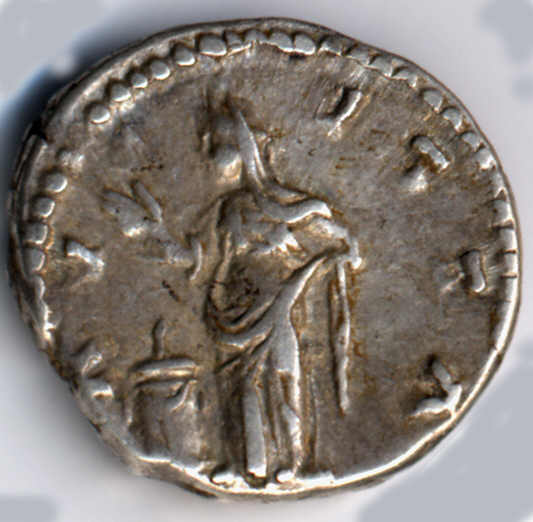
Roman Coins and brooches found in the area of Ash in September 2000. The coins are mostly from Constantinus (wearing helmet) and two are earlier.
|
|
|
Detail of one of the silver coins a Dinaris from the reign of Faucina

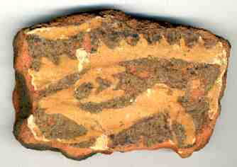
Fragments of Mediaeval Tiles found near the site of Ash Hall in the area of Little Marchams that may have been the site of the Mill House. The upper fragments were found about 100 yards from the lower, and from the location of other debris there were probably two buildings in the area.
Asham can never have been a big village and the “Hall” probably consisted of a main room reaching to the roof with a hole for the smoke from the fire to escape. There may have been one or two other rooms. The house was probably made of timber with wattle and daub in filling although stone could also have been used as there are the remains of a small quarry nearby and there are signs of stone at the probable site as well as brick fragments. Like the Priory, the façade could have been stone with the rest of brick.
Before the Norman Conquest Ash had been held by Azor, son of Titi, Queen Edith’s man (VCH Bucks) who had also held Ifley and other areas. Like Beckley, Ash became part of the honor of St Valery. At the time of the Doomsday book, the village of Studley or Ash was in 1086, held by Roger d’Ivry. Roger d’Ivry held 2 hides of land at ‘Lesa (Ash) and Picot held of him, with 2 serfs on the demesne and 4 villeins and 2 bordars. (Beckley itself had 6 serfs on the demesne, 11 villeins and 6 bordars (A smallholder) making the combined village of about 100 persons). (A Vellein is a Norman term for a tenant of manorial land) Ash therefore had four farms and six smallholdings and probably covered the area marked in the 1641 as Asham Mead, Asham Marsh and Asham Mead as well as lands around Hall Close. The doomsday book records a wood at Beckley and one at Ash for 200 swine. The latter may be Priors Wood (part of Whitecross Green) at Studley. At one time the woodland in the area of Studley Wood Golf Club was more extensive and formed part of Henry II’s hunting park.
At the Norman conquest and until
1884, most of Ash or Asham was in Buckinghamshire as a part of the Hundred of
Ashendon. There is no evidence that it was ever included in the parish of
Boarstall, although the map in the Victoria County History for Buckinghamshire (VCH)
suggest that was the case.
As Asham is not mentioned
in the Doomsday book for Buckinghamshire (or does not have a single mention in
the VCH) suggests that the hamlet was of little significance at the time.
It maybe that as Asham was on the Oxford side of Bernwood Forest and only
easily accessible from Oxford Direction, it was not considered a part of
Buckinghamshire by the lords of Boarstall or Brill, especially as Asham had been
granted to other lords of the manor.
Boarstall in turn had
previously been in the Parish of Brill. Only Brill is mentioned in the
Doomsday book as the Manor of Brunhalle. Boarstall is mentioned after
1213, probably within the serjeanty of Bernwood Forest, known as Burchestala.
When Boastall Tower and manor was built in about 1312 by John Handlo it was
called Burcstall or Borgstall and later Borstall. It was not known as
Boarstall until 16th Century.
Boarstall Tower was
not fortified until much later but that is another story.
Bernwood Forest was granted to "Neil" by Edward the Confessor, and this included Boarstall. Part of the forest that is now part of Whitecross Green Woods was granted to Oriel Cottage in 1586 and the Victoria County History for Buckinghamshire suggests that Old and New Arngrove fields along with Stonehouse fields were enclosed before 1577. There were also habitations at Pauncehall (Paunsale or Pancell), in the Forest of Bernwood. The name is now retained as "Panshill".
There was occupation since the Roman period and Roman pottery, tiles and glass fragments can also be found in the area of Ash and Horton, along with thousands of oyster shells, once the diet of the peasants. The Roman fragments were found on the site where the windmill once stood. Not that the windmill was Roman but because it stood on the highest point that was chosen for a Roman building. There are also signs of smelting at the site.
.
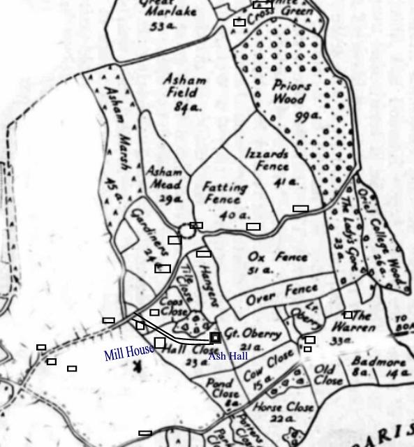
Possible locations of the buildings in Ash area prior to the 17th century showing the location of Ash Hall. The lane from the hall leads down to what is now the end of Mill Lane carrying on to Asham Marsh. The circle to the east of Gardener's is marked on the map in the VCH as the presumed site of Asham.
Marlake now a part of Murcott, (or Moorcot) was a part of Ash and Studley. Merelake was formerly part of the preceptory of St John of Jerusalem at Sandford. It is possible that the Hospitaller’s estate at Marlake in Ash was part of lands granted to the Templars between 1190 and 1212 by the Ash and De Bosco families. The Templars had probably left the lands before 1279; for the Hundred Rolls do not record that they have any holdings in Beckley parish. The Croke family described Marlake as a separate manor.
In the 13th century we see fields being divided, The Terrier (a written description of landed property by acreages and boundaries) records that Horton fields to the southwest to the northeast had been divided into smaller fields Westfield, Morefield, Eastfield (later known as Ash field). In 1292 two enclosures were called Newland and Northcroft and two open fields at Ash (Esses), Essemfield (Later Ashamfield) and Holdburyfield, later to become Great and Little Oberry. There were also several crofts and enclosures. At Marlake, in the manor of Ash, there was common land at White Cross Green and assards (Land cultivated out of felled woodland) from Otmoor and Bernwood (Fattingsacre, Blackred, Middlefurlong, Betneeshall, Six Acres) and two strips called East and West Stoneyfield later to become the Mill Field in Studley.
According to The History of Oxfordshire (V. C. H.) there are some 13th century references to the lord’s mill referring to the mill at Beckley and also another mill at Horton. The vicar had a “Mill House” in the vicarage grounds of the 17th century Studley Mill, which John Croke acquired with the priory estates in 1539. This “Mill House” is not shown on the 1641 map and presumably was demolished. This may have been a house in “Ash” and may have been the house below the Windmill where medieval tiles have been found. Marlake was also an early settlement (now Murcott) and the name survives as Marlake Lane and Marlake House (once a public house) and Nash End on the OS map.
Between 1190 and 1200 three brothers, John, William and Walter of Ash held the manor of the St Valery’s and another part was held by their kinsman William de Bosco whose lands in Ash were assessed at 4 carucates in 1220. (carucate – originally a Danelaw area of plough land assessed for taxation between 160 & 180 acres but by 1086 it had come to mean a unit of taxation).
In 1242-3 John of Ash held the manor of Richard of Cornwall of the fee of Beckley. In 1278-9 Nicholas of Ash held 10 virgates there of Edmund of Cornwall by military service. (virgate - usually a quarter of a hide, about 30 acres of arable land scattered among the common fields of the manor but could vary, sometimes known as a yardland). It can be assessed that Ash covered an area of 300 acres and this will have covered the area that includes Studley.
It was during this period that the only surviving house in the village from the 13th century was built. The Old Weir is the oldest house in Horton cum Studley and probably in Oxfordshire with cruck construction dated to about 1250. Side Purlins and Wind Brace can be seen in the bedrooms with the Cruck Blades visible downstairs.

Internal view of The Old Weir
The prioress of Studley Priory, William Lock and Peter of Ash were tenants at Ash for 6 of the 10 virgates. In 1300 Nicholas of Ash’s lands were described as three parts of a knights fee belonging to the honor of St Valery.
Neil of Ash was said to hold Ash with Marlake in 1316. Roger, son of Nicholas of Ash, is mentioned in 1323 and the manor passed to Roger’s son John, who in 1361 “enfeoffed” (passed over the land) to John Appleby, Lord of Boarstall and his wife Margaret, granddaughter of Sir John de Hadlow. In 1389 Ash was passed to the Prioress of Studley who held the lands until the sale of the Priory to John Croke in 1539.
Asham Hall had disappeared by 1641. The Hall probably went into disuse after the lands had passed to the priory in 1389 and the stone and bricks used to extend the Priory buildings. It is not surprising that little remains, although remains of foundations could be seen until the 1970s when they were destroyed when the land was ploughed. The original hand made bricks in the domestic area of Studley Priory have yellow streaks the same as found on brick fragments from the area of “Ash”. There is some doubt about exactly when the Hall and other buildings were demolished as 17th century tiles and pottery can be found on the site.
![]()
Firstly we need to know where is the boundary between Horton and Studley. The clearest definition is given in the 1827 enclosure act of the Parish of Beckley. A copy is held in the county record offices in Cowley. It clearly defines Horton as the Oxfordshire part in the parish of Beckley, and Studley being over the border in Buckinghamshire. The border then being the lane from the Brill Road to Gardener's barn then the stream flowing down to Otmoor. So why was Studley Priory not called Horton Priory? It could be that the lands given to the prioress was half in Buckinghamshire, and maybe they first used the buildings at Asham, Bucks. However that is speculation. The 19th century censuses talk of Studley, Bucks but after a county boundary change in the late 19th century (the act preceded the actual acceptance of the border changes and there is no evidence as to exactly when the Studley became part of Horton). Latterly it has been assumed that Horton is the area west of Mill Lane and the Oxford Road, corresponding to the original Earl of Abingdon's estate, and Studley to the east, corresponding to the original Priory estate. This clearly is not true.
The interesting fact is that there is no mention of Studley (or Asham) in the Buckinghamshire county history or any document in the Aylesbury library. There is mention in the Oxfordshire County History (VCH Oxfordshire). It seem therefore that although Studley was in Buckinghamshire and because the Prioress and later owners of the Priory administered the village that it became a de-facto part of Horton from early times.
Horton had
a number of owners from the time of the Norman Conquest.

The map of the Parish taken from the 1641 map and later OS Maps
The barony passed to John de St. John and Roger St. Valery, either jointly or in turn, but it is likely that it came to them with an Ivry heiress or heiresses. Roger (II) d’Ivry had a sister, Adeline, but little is known of her history. Reynold of St. Valery supported Empress Maud against King Stephen in the civil wars, and in 1158 went on crusade. He died probably in 1166-7 and was succeeded by his eldest son Bernard, who in 1166-7 paid a fine for livery of Beckley and Horton. He seems to have died shortly after 1191, and was succeeded by his second son Thomas, who paid a relief in 1191--2. Not long afterwards, Beckley and Horton, along with his other lands, were seized by the king, and in 1196-7 they appear among the escheats, no doubt as a consequence of Thomas's support of Philip Augustus in Normandy. Between 1198 and 1215 Thomas changed sides at least three times, alternately regaining and forfeiting his English lands. He finally made his peace with King John in 1215 and died early in 1219 leaving as his heiress his only daughter Annora.
In 1210 or 1211 Annora had married Robert de Dreux, eldest son of Count Robert II o£ Dreux, and brother of Peter de Dreux later Duke of Brittany. Robert consistently supported Philip Augustus against King John, but made his peace with Henry III in 1217. He became Count of Dress in 1218 and in February 1219 was awarded the lands that Thomas of St. Valery had held in England. By the end of 1226, as he had again chosen to side with France, Henry III seized all his English lands.
In 1227 Henry III granted all Robert de Dreux's English lands to his brother, Richard of Cornwall. The grant was confirmed by charter to 1231. Under Richard of Cornwall, Beckley, as a part of the honor of St. Valery, was the most important of the five demesne manors of the honor in Oxfordshire‑the others being Willaston, Blackthorn with Ambrosden, Asthall, and Yarnton; the honor was sometimes called 'of St. Valery of Beckley'; or simply `of Beckley'.' Richard's tenure at Beckley suffered one brief interruption after his capture by the Montfortiana at Lewes in 1264, but he recovered his lands in 1265 after Evesham Richard died in 1272 and was succeeded by his eldest surviving son, Edmund, who held the manor of St Valery, including Beckley and Horton for 28 years.
He died in 1300, leaving no children, and his cousin, King Edward I, inherited his lands. Beckley and Horton were among the lands which Edward I granted for life to Roger Bigod, Earl of Norfolk. In 1302, on Roger's death in 1306 they reverted to the Crown.
In 1308 Edward II gave Beckley to Hugh Despenser the elder, who later in the same year, leased the manor for life to his follower Sir John de Hadlow, who had been keeper of the manor and park in 1307. When the honor o£ St. Valery was conferred upon Piers Gaveston in 1309, Beckley was excluded.
The alliance with Edward II's favourite brought trouble to Hadlow, when the marchers ravaged the Despenser lands in 1321, his manors in Oxfordshire and Buckinghamshire were looted. Sir John held onto Beckley and in 1337, Edward III conceded that he should hold the manor for life.
Although Boarstall was Sir John's principal residence, there is evidence that he lived at Beckley, where his granddaughter was christened. The manor does not appear in the inquisition taken after Sir John's death in 1346 and the lands passed to the Black Prince, perhaps because as caput of the honor of St. Valery it was considered to belong rightly to the, prince's duchy of Cornwall. In 1356 the prince granted Beckley to Sir John Chandos as part of his reward for his good service in France. Chandos was to hold the manor. However, only for the life of Juliana, Countess of Huntingdon and Beckley Park remained in the prince's hands.
Juliana died in 1367 and in 1371 Beckley was granted to Sir Nicholas Bond, a squire of the prince's chamber but by 1374 it was back in the possession a£ the Crown. William Montage, Earl of Salisbury, secured an exemplification of his father's grant in 1378, he did not obtain possession and in 1382 Richard II gave Beckley to Queen Anne in dower. In 1346 Richard le Forester had been appointed by the Black Prince to keep Beckley Park and held his office for nearly forty years. He lived nearby at Stanton St. John.
In 1394, after the death of Queen Anne, Richard II granted both the manor and the park to Sir John Golafre, a knight of his household whose family held a number of manors in Oxfordshire and Berkshire. After his death in 1396, Beckley was granted to Philip de la Vache, another of the king's knights. Philip served as Chamberlain to the Queen under Henry IV, who confirmed him in possession of Beckley. Philip was dead by 1408. Henry V's grant of Beckley in dower to Queen Katharine was confirmed by his son's first Parliament and she was recorded as in possession of the manor in 1428.
For the rest of the 15th century the manor remained in the hands of the Crown, though numerous administrative appointments, some of them sinecures, were made there: the Stewardship of Beckley, for instance, was one of many offices held by the Duke of Suffolk. Beckley Park, however, changed hands frequently between the death of Queen Catharine (Catherine de Valois, wife of the late Henry V) in 1437 and 1550, when it was reunited with the manor.
In 1438 another John Golafre and Sir Edmund Hampden were appointed joint Keepers of Beckley Park The former died in 1442, and in 1445 Hampden was confirmed as sole keeper for life and seems subsequently to have lived at Beckley. Sir Edmund, one of the famous Buckinghamshire families, was a Lancastrian. He was consequently attainted on the accession of Edward IV in 1461, and Beckley Park passed into the keeping of a Yorkist. Ten years later Sir Edmund was slain at the battle of Tewkesbury.
His successor at Beckley was John Stokes of Bignell, Bicester, who kept the park until his death in 1476. From 1465 onwards William Stavely of Broughton Stavely (Bucks) was associated with him as joint keeper. In 1484 Thomas Fowler, a trusted follower of Richard III, was made Parker of Beckley, but his tenure of office did not survive the change of dynasty in the following year.
In 1486 he was replaced by Ralph Verney, the Lancastrian grandson of the prominent Yorkist of the same name. Henry VIII renewed Ralph's grant in 1513 and included in it his son John, of whom nothing seems to be known. Ralph died in 1525 and John must have predeceased him, for in 1526 Beckley Park was to be let. In 1530 Sir John Wellesbourne of Fulwell (Oxon.), squire of the body to Henry VIII, received a lease for 21 years. In July 1547 the Protector Somerset acquired Beckley Park in augmentation of his honor of Ewelme, but later granted its reversion to Sir John Williams. In March 1550 Beckley manor was granted to the Princess Elizabeth in accordance with Henry VIII's will but in April Sir Walter Mildmay, a surveyor of the Court of Augmentations, obtained a grant of it, and conveyed it to Sir John Williams, later Lord Williams of Thame, who reunited park and manor.
Lord Williams died in 1559, and passed Beckley and Horton to his daughter Margeret and her husband Sir Henry Norreys, who became Lord Norreys of Rycote in 1572. In 1580 Beckley was held of Lord Norreys by Christopher Edmonds and Richard Huddlestone, for an unknown term of years, but in 1598 Lord Norreys and his wife passed the manor to Sir Anthony Powlett and others for certain uses, perhaps connected with its settlement upon their grandson and heir Francis, son of Sir William Norreys.
Horton had been held with Beckley by Edmonds and Huddlestone, but in 1589 it was separately conveyed to Lord Burghley and others as security for a loan made to Lord Norreys. Francis succeeded to his grandfather's title and estates in 1601. In 1602 he conveyed Beckley and Horton to his uncle, Sir Edward Norreys, but regained possession on the latter's death in the following year. In 1621 Francis was created Viscount Thame and Earl of Berkshire, but in 1624 he ended his notably violent career by committing suicide. Beckley next passed to Francis's daughter, Elizabeth, Baroness Norreys, and her husband Edward Wray, a Groom of the Bedchamber to James I.
On Elizabeth’s death in 1645 her title and the lands descended to her daughter Bridget, whose first husband, Edward Sackville, died a prisoner of the parliamentary Forces. Her second husband was Montague Bertie, Earl of Lindsey, a prominent royalist, and on her death in 1657 her estates passed to her son James Bertie, Lord Norreys who was created Earl of Abingdon in 1682. Beckley and Horton remained part of his lands and remained in the hands of successive Earls until 1919 when it was sold in Lots. The early 19th century maps of Horton cum Studley shows that Horton was mostly owned by the Earl of Abingdon and the Croke family owned Studley.
By the late 16th century there were four open fields at Horton. By 1609, the entire manor of Ash with the exception of the Mill Field was enclosed in compact farms. Rents of enclosed farms in the fields totaled £54 18s 3d of which part was for strips in the Nash and Horton. By contrast, rents of the enclosed farms totaled £330. The yearly sum of £140 was paid for Marlake and Asham Fields and Oxvent and £45 for Middle Marlake. The rent for Warren Farm was 300 couple of conies (rabbits) valued at £40. There appeared to have been disputes over the land between the Norrey’s and Croke over the area towards what is now Whitecross Green Woods. Both claimed the right to enclose Asham Marsh, Pinfold Green Long Acre, Short Acre and Arnegrove. After legal wrangling Croke won by verdict of Aylesbury court in 1557-8. There were other disputes at the time especially over waste ground known as the Stonehurst of 400 acres used as common by Horton, Studley, Stanton St John, Wormingall, Boarstall and Oakley.
The grazing rights on Otmoor were controlled by the lords of Beckley and in 1582 “a servant of Master Croke” was charged with keeping sheep dogs on Otmoor contrary to court orders.
There were many rules for the use of Otmoor, laid down between 1580 and 1656. The moor court chose two men each from Beckley, Horton, Fencott, Charlton, Oddington and Noke to regulate the rights of the common. This appears to have gone with occupancy of a house. The court laid down the number of sheep and geese that could be grazed and laid down heavy penalties for keeping diseased horses and pigs.
Fines for
breaches of the orders were normally shared between the lord of the manor of
Beckley and the hayward (official of the manor responsible for the hedges) and
moor men. Forfeits went to the
lords of Beckley, as in 1657, when John Coxhead's cattle and 6o sheep which he
had on the moor were declared forfeited after he had `murthered himselfe'
![]()
Enclosure
Act and Draining
of the Moor.
The
draining of the Moor and enclosures seems to have come from the surveyor of the
Abingdon estates in 1728, when it was his chief proposal for improving the value
of the manor Some small enclosures had already been made, but he said that they
were so ill used that they were chiefly overrun with bushes.
No action followed, but in 1787 Sir Alexander Croke put forward a scheme
for drainage and enclosure. Arthur
Young also thought it ‘a scandal to the national policy' that Otmoor, within
five miles of Oxford and the Thames, should remain unenclosed; and considered
that its `good loam would form valuable farms, if drained, for tillage or
pasturage'‑certainly for the latter Opposition, however, from the Earl
of Abingdon, who was supported by the representatives of 340 families of the
Otmoor villages, defeated the plans to secure a parliamentary bill.
The next
proposal to enclose came to Parliament from George, Duke of Marlborough, and
others, in 1801, but this time Croke and John Mackarness claimed that their
interests as landowners had been disregarded, and the bill failed in committee.
On 12 July
1815 an enclosure bill, including a major drainage scheme, was at last passed.
The final award was not completed until 15 April 1829, though in the
lawsuits which followed, the proprietors claimed to have enjoyed fourteen years'
peaceful possession of their new lands before 1830.
Beckley
parish interests received the following allotments: Beckley township, 303 a.;
Horton hamlet, 262 a.; Studley hamlet, 200 acres; the Earl of Abingdon, for the
lord paramount's right of soil, 107 acres; Sir Alexander Croke for tithes, 102
acres.; and the Revd. Theophilus Cooke for tithes, 63 acres. The commissioner
was empowered to split up the communal awards among individuals if those
entitled to the major part in any village desired it. But the Beckley parish awards were not apportioned until the
general enclosure of the parish. Beckley's
allotment went almost entirely to Abingdon and Cooke, Horton's to Abingdon
except for a small amount to Cooke, and Studley's to Sir Alexander Croke.
The open
fields of Beckley parish were enclosed by Act of Parliament in 1827 though the
award was not completed until January
1831. The Earl of Abingdon, as
lord of the manor of Beckley with Horton, Sir Alexander Croke, as lord of
Studley and lay impropriator of most of the tithes in the parish, George Leigh
Cooke, rector of Cubbington, as the impropriator of Beckley rectory, and his
nephew, Theophilus Leigh Cooke, as perpetual curate of Beckley, shared the award
between them and bought in almost all the land which was sold to defray the
expenses of the award. The only other freehold allotments, four in number, were
all small. Ralph Butler of the New
Inn bought 8 acres under the sales. There followed many exchanges among the
three main beneficiaries to consolidate their holdings, in the course of which
Horton Wood was acquired by Sir Alexander Croke of the Earl of Abingdon.
The
copy of the act Act is held at the Centre for Oxfordshire Studies in Cowley,
“For enclosing the lands in the Parish of Beckley 28 May 1827”
The act designates the public roads
and footpaths in the Parish as follows:
Horton and Oxford Road
One other Public Carriage Road and Highway of width 33 feet from the King’s
Arms, Bicester Road to SE corner of Chapel Close, to Beckley. (Chapel Close
must be what is now Church Lane, although the church was not built until 1868.
This indicates that there was once a chapel on the site.)
The Bicester Road.
One other Public Carriage Road and Highway of width 33 feet leaving the said
Horton & Oxford Road at the south east corner of Chapel Close and proceeding
in a westerly direction nearly in its present track by the pound to a cottage in
the occupation of John White on Lower Green, thence in a northerly direction
over the said Green into the Little Marsh and then continuing in a northern
direction over the same to the commencement of a road set out under the Otmoor
enclosure.
(This describes what is now
Ragnall’s Lane. The pound used to be at the start of what is now Ragnall’s
Lane next to Ragnall’s House. John
White probably lived in what is now Ragnall’s House.
Note: there is no mention of Ragnall in any old document or archives and
the origin remains a mystery. )

Ragnall’s
House as a cottage circa 1930
The Brill Road One
other Public Carriage Road and Highway of width 33 feet leading out of the last
described road and commencing at the west end of Upper Green near the premises
of Abraham Hillesden and proceeding in its present track until it enters the
township of Studley in Buckinghamshire. (This is now known as Brill Road.
Abraham Hillesden probably lived in the thatched cottage once known as
Corner Cottage at the junction with Oakley Road and Horton Hill)
The Thame Road
one other Public Carriage Road and Highway of a width of 33 feet leading out of
the last described road at the commencement thereof and proceeding in a south
east direction over the Upper Green and Horton and Carbridge Commons to the
parish of Boarstall at Poor Folks Pasture Oak.
The Lower Green Road
One other Private Carriage and Occupation Road and Public Highway of a width of
30 feet leading out of the Bicester Public Road and proceeding along the west
side of Horton Lower Farm into Holland’s Field. (This is the road from
Church Lane to West Hill Farm)
Mills Lane Road
One other Private Carriage and Occupation Road and Public Highway of a width of
30 feet leading out of Bicester Public Road at the cottage in the occupation of
William Haynes and proceeding along Mills Lane to a house and ancient enclosure
belonging to the Earl of Abingdon with occupancy of Edward Crick.
(This is now Mill Lane, it was probably named after Thomas Mills who lived in the Lane and had land in the village (see 1641 map). William Haynes probably lived in the Thatched Cottage that was once the village shop.)
The Stanton Wood Road
One other Private Carriage and Occupation Road and Public Highway of a width of
20 feet leading out of Horton and Oxford Public Road and proceeding along Horton
Common to the gate in the Parish of Stanton St John. (This could be the
public footpath that goes from opposite the entrance to Beckley Park past the
gas sub-station)
Other minor roads and footpaths
The Stanton Footway
4 feet wide from the Beckley Oxford Road
Horton Noke Footway
Horton Beckley Footway
The above are not described as they
led across then un-enclosed land. However footpaths remain to Beckley, Noke etc
Horton to Bicester Footway
4 feet wide leading out of Horton at the homestead of Samuel and Mary Blake and
proceeding in a north westerly direction into and across the Bicester Public
Road over the Nash Field until it enters Studley in Buckinghamshire at the stile
in Otmoor Furlong near Cuckoo Pen.
The Brill Footway.
4feet leading out of the village of Horton between two small old enclosures
belonging to the Earl of Abingdon in the occupation of Thomas Budd and
proceeding in or near its present track over the Mill Field and past the
windmill until it enters Studley in Buckinghamshire.
The Oakley Footway
4 feet out of the Thame Public Road and proceeding in or near the present track
across Horton and Carbridge Commons to a stile in the boundary fence in the
parish of Boarstall.
Studley and Stanton Footway
… out of the Thame Public Road at the bridge or tunnel over the same and
proceeding in a south westerly direction over Carbridge Common into the Stanton
St John Public Road opposite to a gate there in the parish of Oakley.
Horton and Stanton Footway
… Horton and Oxford Public road two yards west of the Bridge over the public
drain and proceeding in a south direction to a stile in the boundary fence of
the parish of Stanton St John.
Horton Common Drain one public drain
width of seven feet commencing at the pond on Horton Common and proceeding in a
north westerly direction over Vent Field and Holland Field into the drain on the
south side of Otmoor.
And I do hearby award that
the grass and herbage arising on the said roads which are not within or leading
over any attachment or allotment shall ever belong to and be the sole right of
the proprietors of the lands and grounds within the said parish of Beckley next
adjoining the said roads respectively on either side thereof as far as the crown
of the road.
Each page is signed by Thomas Barford
As well and the big landowners – The Earl of Abingdon and the Croke family, the act also mentions grants to Elizabeth Bulford, widow, and Samuel Jacobs in 1770 and 1774.
In
the meantime, the Otmoor enclosure had been having unexpected consequences. The
immediate social effects were distressing: contemporary evidence shows that the
small-holders and cottagers had been able to make £20 a year out of keeping
geese on the coarse aquatic grass of the moor, and that the fowling and fishing
had provided valuable food. Enclosure deprived them of these sources of income,
while the mitigation of the chronic disease called the moor evil, possibly foot
and mouth disease, of which the improving landlords had complained, was perhaps
more advantageous to the large farmer than to the small one.
Furthermore, the sanguine hopes of the 'improvers' were not realized.
It seems that the floodwater which they had considered the moor's chief
bane may have given it what fertility it possessed. Instead of the land becoming
worth some 30s or 40s an acre, as Arthur Young had predicted, it was considered dear,
some ten years after enclosure, at 5s an acre.
Also the vast amount of hedging, ditching, and major drainage operations
involved made it one of the costliest of parliamentary enclosures, and only the
large landowners could afford to take up their allotments.
General discontent came to a head in 1830, when much valuable land was flooded because the commissioner had cut a new channel for the River Ray at a higher level. Twenty-nine farmers who had suffered considerable loss united to cut the new dykes to allow the river to return to its ancient course. They were sued by the rectors of Oddington and Beckley; indicted for felony at Oxford Assizes, and acquitted. Wholesale uprooting of fences and mass perambulations of the moor followed this verdict. The summoning of troops, the arrest of 44, men, the attempt to convey them to Oxford castle through the midst of St. Giles' Fair and their rescue by the mob, were fully described in the local newspapers. Some of the rioters were later sentenced at the assizes to imprisonment and fines, but recommended to mercy. Subscriptions were opened in aid of the Otmoor villagers by an Oxford wine merchant, who was later successfully sued for libel by Sir Alexander Croke. A pamphlet war ensued and associations, called Otmoor Associations, were formed to fight for the rights of Otmoor commoners.
As late as 1833 two men were indicted for malicious destruction of a bridge built by order of the trustees of the Otmoor drainage scheme.
![]()
Otmoor
Farming
In the 13th century Horton was the most prosperous part of the parish. In 1279 after the lands had come into the lands of Richard of Cornwall, Horton had 11 villein virgaters, 11 cottagers and 1 free tenant. Horton land was more productive than Beckley or Studley. A tax list of 1327 shows that of the 13 Beckley contributors, only 4 paid as much as 3s to 4s, and in Studley out of 11, only 1 passed the 3s level with his 6s contribution. At Horton 14 out of 23 contributors paid between 3s and 6s 6d. The 1377 poll tax figures show the same trend. They give an adult population of 78 to Beckley, 96 to Horton and 53 to Studley. Horton being the biggest hamlet.
By 1582 Beckley had 35 taxpayers and Horton 47. In 1676 there were 336 churchgoers at Horton and only 16 in Beckley. In 1676 many of the churchgoers worked at the Priory. The first census report of 1801 gave a Beckley Parish (including Horton and Studley) number as 691 and reached 825 by 1821, after which there was a steady decline to 513 in 1901.
There were other wealthy families other than the Croke family in the 16th century, Thomas Biggs was assessed on £10 of goods in 1559 and in 1563 he was left lands in Woodstock and Hansborough by the widow of John Coventre, gentleman who appears to have come to Horton from London in the service of Sir John Croke. Thomas Biggs died in 1611. Among other families mentioned were Vicars, Brown, Badger and Chillingworth, living at Horton.
The Survey Book of 1786 shows that James and Thomas Ledwell held 47 and 43 acres respectively in Horton manor.
From the early Middle Ages much of the land between Beckley and Horton was an enclosed park where the lords of St Valery and later Kings of England hunted. The earliest record of it occurs in 1175-76 it was being enclosed between 1192 and 1197 with a stone wall, the remains can still be seen east of Beckley and in 1229 Richard of Cornwall stocked it with deer and then constructed a deer’s leap. Lower Park Farm was the location of the hunting lodge (now called Beckley Park). Some of the ancient wood survive (not necessarily a part of the hunting park), Studley Wood (once Horton Wood), Upper Wood (formerly Lady’s Gore) and Whitecross Green (once Prior’s Wood)
The village of Horton houses were scattered and many of them had no road outlet. On the hill above, where Studley Priory was built in 1176, several new houses are appeared at the same time. There is evidence that there were houses in the lower part of Horton cum Studley, in the area to the north of Church Lane. An early map shows a circle of houses round the green. The village ponds still remain in the field.

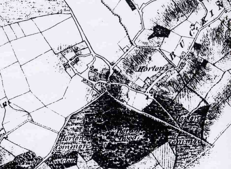
Part of an 1641 map showing Horton and Nash. This map has north to the bottom. There is no mention of Studley but the map is titled "Nash Field"
Horton cum Studley 1811 - showing old county boundary with Bucks being just beyond Studley Farmhouse. Also note the Priory "by pass" and a lane and buildings opposite today's playing fields and village hall.
![]()
Studley
Priory
Studley Priory was built in 1176 as the Church of St Mary for holy women of the Benedictine order in the reign of King Henry II, by Bernard de Valoni, a friend of Price Richard (Coeur de Lion). The priory was supported by lands in Crawcombe in Somerset and Corsley in Wiltshire plus local lands in Ash and Marlake (now Murcott). The valuation of the income in 1539 was £102.6.7d. The Ash lands as shown on the 1641 map as part of the Priory estate show lands opposite the Priory to the north where the windmill once stood. Marlake is retained in a local field name in Murcott and was once the name of the area now called Murcott but also spelt Moorcot in the past.
Marshall, in his Oxfordshire Byways, gave a very good description of the country in the old days:
“In their seclusion the Benedictine sisters saw the herds of cattle feeding in the green pastures, and in the winter flood-time they watched the wild duck winging its way. On May-day year by year they welcomed the men of Charlton who came across the moor to the Priory, carrying with them the image of the Virgin, the patron saint of the convent and their church. The herdsmen of the district paid them a tithe of their beasts and their cartulary contains a description of that land of Otmoor which was held in common by the dwellers in the seven towns. It is so great and notable a quantity of ground, so beneficial a common, so profitable for fowling and fishing to all the inhabitants of six or seven townships, bordering round it . . . who have ever used and enjoyed the right of common for all their flocks of sheep, herds of beasts and all manner of cattle at all time, and have taken and enjoyed the fishing and fowling at their pleasure at all times, none of the said townships claiming any pre‑eminence or greater right than the rest.”
At the time of the Black Death in 1356 it was reported that there were about 50 nuns at the Priory. This is considered an exaggeration and it is thought that the number was more like twelve. The visitations of 1440, 1445 and 1530 gives details of the nuns:
The visitation by Lord William Alnewyke, Bishop of Lincoln lists the nuns and gives an insight into the way of life. The Nuns listed were:
Dame Elinora Cobcote, Prioress
Margareta Niernute, Sub-Prioress
Agnes Devyle, Tercia prioressa
Agnes Devyle said that nuns may visit friends for nor more than 3 to 4 days, that they wore silken veils and robes, with veils down to the eyebrow. She said that the last prioress for 58 years never rendered an account. Thomas Halle was the steward.
The Priory
was in the Archdeaconry of Oxford and Deanery of Cuddesdon.
The visitation of 26 April 1520 says that the Prioress was Katherine Cobot (1515-1529) with Isabel Copcote sub-prioressa; Alice Smyth, sacrisa; Alice Wychill, precentrix; Margaret Welsh, refrector aria; Alice Copcot; Alice Edmund; Agnes Banyard; Johana Williams; Joanna Dormer. Johanna Willams became prioress in 1529.
The visitation of 20 September 1530 to the Prioratis de Studdelegh by Ricardum Hill lists the nuns:
Alice Whyghyll (Whitehill) Prioress but about to hand over to Alice Richardson
Margaret Walshe, Alice Copcote, Alice Yemens, Felice Asshley, Lettice Wyncot, Margaret Hampden, Helen Smythe, Joan Hede.
It is interesting to note the number of Copcots who joined the Priory.
Cardinal Wolsey is believed to have obtained the permission of one of the Prioresses of Studley Priory to cut down timber for his new college at Oxford that was to be called Cardinal College (now Christ’s Church) and thus decimated Studley woods.
Following the dissolution of the monasteries by Henry VIII the Priory was bought by Master John Croke who made his way in the royal service to become Master in Chancery under Edward Vl. Master Croke bought land and built his manor house at Chilton, near Thame, adding Studley Priory to his land purchases in 1539 at a cost of £1,187 7s 11 d. The purchase of Studley Priory had all the hallmarks of a good investment to rival that of the famous "Little Jack Horner" of nursery rhyme fame, the lead from the church roof making a considerable contribution towards the purchase price. The estate survey of 1641 with minor boundary changes is the Priory estate transferred to Master Croke.
Master John Croke was succeeded by his son, a second John. The latter was appointed the first High Sheriff of Buckinghamshire and at the same time received his knighthood. The very fine tomb in Chilton church commemorates Sir John and his wife; a line of small figures along the front of the tomb indicates by their costumes the honours acquired by his children during their lifetimes.
Studley Priory was deeded by the above named to his eldest son, a third John, in 1584. This John Croke followed the legal profession and ultimately held important appointments, being Recorder of London and Speaker in the last Parliament of Queen Elizabeth, he was appointed to the King's Bench and knighted under James 1. Sir John Croke carried out the alterations to the Priory building to form his manor house though he moved to the family manor at Chilton on the death of his father. The second son of the first Sir John Croke, Henry, who became Clerk to the Pope in the reign of Charles I, married an heiress Bridget Hawtry and built his manor house at Chequers in the Chilterns, now the country residence of the Prime Minister
George Croke in common with his elder brother followed the legal profession; he was knighted in 1623 and became a justice of the King's Bench in 1628. His legal arguments survived him by many years and even today are quoted by lawyers. One of the most famous cases in which he participated was that of the 'Ship Money' trial; Charles I in one of his endeavours to raise money without the sanction of Parliament extended the tax paid by the coastal counties for the provision of naval vessels to inland counties. As a result of his refusal to pay the tax John Hampden was tried and sentenced to imprisonment. Sir George's arguments caused both Houses of Parliament to vote against the judgment and secured Hampden's release. Sir George added the chapel and provided a stipend for a clergyman to preach there, he also built and endowed the nearby almshouses. Sir George had one son, Thomas, of whom little is known.
By Sir George's will Studley Priory passed to his brother William for his lifetime with entail to William's son, Alexander. Possibly due to confusion of records during the Civil War years the death of William is not recorded, there is therefore no certainty that he occupied the manor.
Alexander built the stable block to the north of the chapel using materials recovered by demolishing the east range of Priory buildings. Alexander Croke married twice and at his death left Studley Priory to his grandson by his first marriage, John Croke; to his son, Wiliam, by his second marriage he left that part of his property in Buckinghamshire. John Croke left three children, John, James and Charlotte. John being incapable of managing the estate passed his interest to James in return for an annuity and on James's death made similar arrangements with Charlotte and her husband, William Ledwell. On Charlotte's death Studley Priory was reunited with the other part of the property under the ownership of Alexander Croke, a cousin and descendent of the first Alexander by his second marriage.
The son of Alexander, another Alexander, inherited the estate in 1796. He was trained in the legal profession and after a conflict with the Earl of Abingdon over the provisions of the enclosure of Otmoor, spent the years from 1800 to 1815 as a judge in the Admiralty court in Halifax, Nova Scotia. On his retirement from this post he received a knighthood. Sir Alexander made some adjustments to the Elizabethan levels of the house and added an extension of three storeys with one room on each floor on the east side of the Priory. Benefiting by the enclosure of Otmoor the estate increased to some two thousand acres and Sir Alexander left this estate in trust to his widow and ten surviving children. By 1877, there being no issue from any of Sir Alexander's children, the two survivors arranged for the trust to be broken and the estate was sold.
In 1877 the estate was bought by John Henderson. His heir Captain Ronald Henderson, served as Member of Parliament for the Mid‑Oxon Division; his alterations included raising the roof of the stable block to provide extra bedrooms in 1924 and extensive improvements of the water supply and drainage.
During the Second World War Studley Priory was used first as a B.B.C. hostel for evacuated London Staff and later came under military requisition. In 1947 the house was let to a tenant who commenced to run it as a country club; the estate was sold and broken up in 1954 and on the termination of the lease the house and gardens were purchased by Mr. E. E. Parke who established the present hotel.
From the history of the owners we now turn to the buildings. When John Croke purchased Studley Priory in 1539 the description of the buildings in the deed of transfer was `ecclisiam cum campanile et domus (church with bell tower and house)'. Fortunately the monastic orders, having established a design dictated by their rules, built to one pattern with minor variations to allow for local topography. The level lawns surrounded on three sides by a low bank on the east side of the existing buildings contain the foundations of those demolished.
The church at the north end together with domestic buildings on the remaining three sides would enclose the cloister garth (a piece of enclosed ground) with the cloisters on the interior walls of the west, north and east sides. Entrance to the cloister garth would be obtained by a passageway through the south range of the buildings, admittance to outsiders being prevented by a locked gate. Access to the domestic buildings surrounding the cloister garth would be from the cloisters. The kitchen and storerooms to the south would form part of the outer court that would be used by the lay servants of the Priory.
Of the surviving buildings, the west range of the Priory buildings was raised to two stories prior to 1450, the construction being that of a trussed rafter roof. Re-roofing of the kitchen appears to date from about 1500.
The land grant to found the Priory establishes the church as being in existence in about 1184, remnants of the worked stone which include pillar capitals provides two dates to the buildings, late Norman and thirteenth century, which may be ascribed respectively to the church and cloisters.
The lay appropriator was required by law to demolish monastic buildings purchased from the Crown, presumably to prevent the return of church inhabitants, though up and down the country the observance of the law varied from one extreme to the other. At Studley Priory it was thought sufficient to demolish the church and no doubt the proceeds from the sale of the lead roof gave an adequate return for this work.
Standing on the circular lawn to the west of the house, the buildings give the impression of having been constructed at one period though, as may be seen from the plan above right there are five building dates.
The porch is an Elizabethan addition to the earlier building, on the left one half of a pair of windows has been eliminated, on the right a three-light window has been reduced to two lights. Above the entrance are the Croke coat of arms impaled with those of the wives of the first three generations: Cave, Unton, Blount and Bennett above that is the family motto `virtutis amore'. The date of 1587 is related to the first three, the Croke-Bennett arms are a later insertion with the date 1622, the three coats of arms having been moved to make space for the insertion. The Greek orders present a mixture of styles that frequently occurred in England before the Inigo Jones period.

Early 19th Century map of the lower part of Horton, map showing ownership of the land

Allotments at the end of Ragnall's Lane where Otmoor Farm now stands.
![]()
The
17th Century
The Hearth Tax return of 1665 lists the head of households and the number of hearths that give an indication of the size and wealth of the families.
The return was divided into:
Horton:
Edward Viccars 1, Widdow Goodman 1, Widdow Collins 2, Christopher Boswell 3. These four families are thought to have lived round the old Green at the bottom of the field behind the present church.
Studley:
Mr Alexander Croke 13, Henry Parker 3, William Surman 1, William Hitchcook 1, William Neibour 2, William Kinge 2, Robert Coxhead 3 (Whitecross Green).
(It appears that in 1665, Studley included the Priory and dwellings in Oxfordshire, and Horton the west part of the villages.)
At the Reformation, the reigning prioress Johanna Williams, who was related to Sir John Williams of Thame (later Lord Williams), in November 1539, signed the deed of surrender to the king and left the priory with those of her nuns who still remained. In February 1540, according to Dunkin, Henry VIII granted to “John Croke and his heirs the site of the Priory of Studley, the rectory and advowson of Beckley as fully as the Prioress had them at the time of the Dissolution”. John Croke paid £1,187.7.11d for the estate. John’s son John became High Sheriff of Buckinghamshire and speaker in Queen Elizabeth’s Parliament.
The earliest map in existence is dated 1641 and shows the village with nine cottages on the Oxford Road (Horton Hill) below the Priory and four above. It also shows the Almshouses built in 1639 while opposite the Almshouses was a large building in front of the Priory that may have been servants quarters. . There are a further seven cottages on Brill Road and three in The Lane (Millss Lane or Mill Lane). There are about four cottages over the border in Brill Road into Buckinghamshire.
The windmill is shown at the north end of the path that extends from Oxford Road to Warren Farm as it joins Shyre Way that roughly aligns to the track to Gardener’s Barn. By this time Ash Hall has gone but the field where it stood is called Hall Close. The map is entitled Nash Field with Horton shown as the area around the King’s Arms (Otmoor Lodge Hotel). The area now Church Lane is not shown on the map and is replaced by the title “A Plot and true Description of the Mannour of Studley in the County of Oxon and Bucks.”
The Mill is shown as owned by Robert Saunders. In 1765 William Ledwell had leased the mill for three lives to another Sanders, and a William Sanders held it in 1786. Robert was probably his son.
The Almshouses are shown. In 1636 Sir George Croke built the almshouses and drew up a set of regulations as to the behaviour of the inmates, who, selected by the owner of the Studley Priory and were to come from Chilton, Waterstock and Beckley. Each inhabitant was to have two shillings a week and every two years “a livery gown of broadcloth ready made for them, of colour London russet”. They could not swear or stay too long in an ale‑house on pain of being expelled, and public prayers were to be held in the almshouse rooms or in Studley Chapel.
Whitecross Green Woods are split into three and called The Lady’s Gore, Oriell Colledge Wood and Pryors Wood. Otmoor is spelt Oatmore. The names of all the cottagers and their land is given. The village of Nash, Ash or Asham is recorded in the field names Asham Marsh (now the BBOWT owned pasture), Asham Field and Asham Mead.
Another prominent name was John Coxhead who farmed at Whitecross Green but also had strips in the Mill Field. It was he who made a survey of the manor in 1639 and was probably the bailiff. By the time of the 19th century censuses Whitecross Green was farmed by the Cox family. This may have been the same family who had dropped the “head”. John Coxhead appeared to have committed suicide in 1657, when John Coxhead's cattle and 6o sheep which he had on the moor were declared forfeited after he had `murthered himselfe'.
The
Warren is another field name on the map, now Warren Farm. There were also a number of farm buildings.
The names are difficult to read but one crofter may have been Bryre?
Radford and another John Coxhead. The
field surrounding Gardiner’s Barn was called Gardiners.
The area to the east of Mills Lane (Mill Lane and up the hill) was divided into Windmill Field and Little Mill Field. The top of the hill surrounding the windmill and the pasture at the end of the lane was divided into strips for local crofters to grow their produce. The names given on the strips include Gom, Parker, Payne and Fellis. There were three cottages down The Lane (Millss Lane), one in the area of the present green barn and two on the other side of the lane. The field (Millfield) surrounding the windmill includes enclosures called Claret Well Furlong. The pond and small copse was market and still is there today. Some of the stones found in the area surrounding the windmill site are painted white. Was the inside or the outside whitewashed?
Also shown as having strips on the Mill Field were Richard Gom whose house was just below the path from the Oxford Road (Horton Hill) to the Mill Field. His family lived in the same house until 1952 and the remaining descendant lives in the Almshouses. Next to him lived George Payne.
Other names going up the hill were Richard Parker, Almshouses, Katherine Towne, Tomas Jelly and William Neighbour living on the Oxford Road (Horton Hill). On Brill Road were the Thomson family at corner cottage, then Clarkes?, William White, Ed Hitchcock, William Winchester, Thomas Nicholls, William Surman and another Parker property who had relatively extensive properties. There were two more names further along the Brill Road in Studley Bucks possibly Yomans and Symons. There were also families called John Mills, Thomas Tellis. There were three houses down The Lane (Millss or Mill Lane) one occupied by William ? where the green barn is situated. One of the others may have been John Mills after whom Millss Lane was named. There were two cottages on the right in what is now the field owned by the Badger family, on being situated on what is now a small hump is the middle of the field where sheep are fed.
In Studley, Bucks Marlake Estate was held by John Dickerson and John Coxhead and the Warren estate (now Warren Farm) of 218 acres was held by Richard Dolbey, leased from the Croke family.
The 1665 Hearth Tax return for Studley shows the houses that were big enough to have hearthe. They were the Priory 13 hearths, Henry Parker 3 hearths (Richard Parker’s son?), Willaim Surman 1 hearth, William Hitchcock 1 chimney, William Neighbour 2 hearths, William Kinge (a newcomer) 2 hearths and Richard Coxhead at Whitecross Green 3 hearths.
The Hearth Tax return for Horton was separate and named four households: Edward Viccars 1 hearth, Widdow Goodman 1 hearth, Widdow Collins 2 hearths, and Christopher Boswell 3 hearths. The Vicars were given as subsidy men in the 16th century. In 1641 Thomas Vicars (father if Edward?) held 14 acres.
![]()
The
18th Century
The next map we have that gives us an insight into the village was an estate map of 1786 that shows considerable changes in the area of the old closures. (The current location of this map is a mystery. It is not recorded in the Bodleian, County Archives or Westgate Library). Several fields had been divided into two. Great Marlake had been divided into four and Asham Field divided into six. The average field size was now about 15 acres. It also indicates that the Great and Little Millfields had been separated by hedges as had Goosey (the former Goosehurst furlong). Today in one field off Ragnall’s Lane the strips can still be seen disappearing into the hedge, indicating the new hedging at this time. In theory Studley was owned by the Croke family and Horton by the Earl of Abingdon. In fact there were strips belonging to the Earl of Abingdon in Studley and vice versa.
Marlake house is not marked in the 1786 map and the land had been divided into four farms. Three are farming from Whitecross Green, Hewett 88 acres, Coates 54 acres and Clark 123 acres including Asham field. The fourth, was held by Moses Blake with most of John Coxhead’s estate plus part of the Warren estate with a farm house at the west end of the Warren. William Tipping held Warren Farm with 180 acres all of which was held by Richard Dolbey in 1641.
James Meers held 33 acres including a homestead at the southern end of Lady’s Gore (top part of Whitecross Green Wood) and three closes between the Warren and Studley village.
John Falkener held the tenancy of 130 acres from probably from what is now Studley Farm House. The land included the Mill Field, Nash Field and Holland Field.
One other tenant Richard Budd leased 9 acres from Alexander Croke who had leased it from the Earl of Abingdon.
In 1786 the manor of Horton consisted of about 1,140 acres. The manor included four common fields; Vent Field, Holland Field, Cut Field and Hash Field. There were also about 150 acres of small enclosures concentrated around Horton village. The largest holding was that of John Faulkener with 95 acres with 9 other tenants with over 30 acres.
The main crops grown were wheat, maslin (rye mixed with wheat), rye, barley, pease (peas) and oats. The open fields were cultivated on a rotation of two crops and a fallow. Sir Alexander Croke incorporated in his leases a stipulation that their farms divided into four parts with a four crop rotation of roots, summer corn, grass seeds and winter corn.
On 18th April 1856, Mallam Auctioneers sold 150 Oak trees and 124 saplings from Whitecross Green and Studley Woods. Although they have been partly re-grown only to be cut down again in World War I and since re-grown again. However no ancient trees remain.
The main building of the hamlet of Horton on the lower ground in the 18th century was West Farm. In 1786 the village had two greens, Budd’s Green and Goose Green At the west end, opposite West Hill Farm, there were two large ones belonging to two farmers, John Faulkener and James Ledwell. There was another substantial house on the corner of Oxford Road and Horton Road (now Church Lane and Straight Mile)
![]()
There was a windmill at Nash/Studley from the 13th Century. It is difficult to say when the windmill went out of action. If is shown on the 1811 map. At the 1841 census the following household is recorded:
David Andrew 35 Baker & Miller no
Martha Andrew 30 no
Ann Andrew 12 no
Martha Andrew 10 no
Edward Andrew 8 no
Elizabeth Andrew 6 yes
Sarah Andrew 4 yes
Mary Andrew 2 yes
John Eales 15 Bakers App no
William Leech 15 Bakers App yes
Ann Ray 15 Bakers App no
The “no” means not born in Oxfordshire.
Elizabeth was born circa 1835 in the village while her older brother Edward was born outside the county indicating that they moved to the village about 1834. The family is not recorded on the 1851 census but the miller is then William Cox. By 1861 census John Coates is the baker but no mention of being a miller. As David Andrew gave up after a few years indicates that the business was not flourishing. William Cox gave it a go but gave up by 1861. It is speculation that the windmill was demolished about 1855. It is not shown on the 1878 map. From the census the miller and baker lived near the Almshouses in 1841.
The Crokes remained the owners of the land until the property was bought by the Hendersons who came from Scotland, in 1877. The property, according to the 1811 map owned by Sir Alexander Croke included the area currently bounded by Mill Lane, Oxford Road, Brill Road across to the Lane to Gardener’s Barn, plus fields on the right at the bottom of Ragnall’s Lane. A larger part of the village was owned at that time by the Earl of Abingdon. Horton was then a part of Beckley parish and Studley a hamlet in Buckinghamshire that included Whitecross Green.
The Hendersons also had a house in Marylebone, London. In the 1851 census the head of the family was Dame Alice Croke aged 70 with her daughter Adelaide aged 50. It is likely that the Priory was sold when Adelaide died leaving no local male heir. They also had a house in Surrey.
The Priory chapel, was the only place of worship then in existence and used by the people of both Horton and Studley, was described by Dunkin. He says that it was a plain oblong building fitted with pews, open seats and a gallery. The pulpit and reading desk were is the north‑east corner and it contained a monument to a Mrs. Charlotte Ledwell who died in 1763 and her daughter Mary who had died in 1748. There was a bell turret and a clock.
The house remained in the hands of direct descendants of John Croke for 335 years. A private chapel was consecrated in 1639 and a North Wing was added in 1666; with these exceptions little change has been made to the exterior of the house since the days of Queen Elizabeth I. The present owners, the Parke family, purchased the house in 1961 and converted it to hotel use after it had been a country club for a few years. An illustrated booklet is available dealing with the History in greater detail.
In 1882 there were four old people in the Almshouses, two men and two women, each being given five shillings a week and firing. They were: Harriett Frost age 73 Widow born Long Crendon, Jane Priestley age 73 Widow born Gloucestershire, John Hicks age 85 widow born Gosford Oxon, John Thornton age 41 born Clare Oxford.
Attendance at church was compulsory and the men attended in their black velvet coats with brass buttons, and the women in black dresses and bonnets.
There was a clay ride between Brill and Oxford passing through Studley Wood, which one of the Henderson family remembered. She also recounts how an old lady used to come to stay the night with them riding a pack‑horse seated behind her groom, with her luggage on a second pack‑horse.
Bricks were made at Riding Hill in Oakley Road near Studley Wood where there is a very good seam of clay. The brickworks was used well into the 20th century. James Green being the brick maker in 1891 who lived on the Brill Road in what is now Horseshoe Cottage.
A walk down Church Lane (Green Road) from the King’s Arms (Otmoor Lodge Hotel) in 1800 would have taken you past a field on your left, owned by Thomas Mills, and then Ventfield Farm and Cottages on the left. On the right was the wheelwright then in 1811 a Mr Blake. There was then a lane leading to the right (now a gateway into the field by the ponds), past the same pond and round the field to come out by Ragnall’s House. The outline of the track is still clearly visible in the field. Just past the pond were three buildings in the part of the field owned by the Earl of Abingdon. This track once went round a green with a number of houses that has disappeared by 1811. On the 1811 plan can be seen the cottage on the far side of this track and a barn to the right, that was only pulled down about 15 years ago.
The turning into Millss Lane (Mill Lane) in 1811 was also different from today. The corner where No 10 Mill Lane is situated was a wide area in front of Lower Farm that included a pond. Opposite the farm where No 1 Mill Lane is situated was a cottage. Proceeding down Millss lane there would have been another cottage on the left behind where No 3 Mill Lane is situated then another pond in the garden of now No 4 Mill Lane. There were then farm buildings and enclosures on the right before finding two cottages on the left where the green barns are located. Carry on down the lane and in the end field was another cottage before reaching the Buckinghamshire border where there is now a small bridge over the stream. The fields on the left were essentially the same as today. However the pasture on the right on the hill was included in the Mill Field. Only a small area of the bottom flat part of the grass slope was fenced. The windmill was at the top of the hill in the centre of the large field.
In 1811 the footpath from opposite the Priory towards Gardener’s Barn was known as the Brill Footpath, and the windmill was shewn at the end of the field.
![]()
20th
Century
The
20th century has bought more changes to the village since the time of
the Croke family. The century
started without many changes and before World War I the village appeared to
prosper. There were three pubs, the King’s Arms, The Green Man that
became the old village hall and the Plough and Harrow that was on the right a
hundred yards down the straight mile. It not thought that the two latter pubs
were open before then as there is only one publican listed in the 1891 census
– the King’s Arms. Many men
from the village served in the Army between 1814 and 1918 and there is a
memorial to them in St Barnabus Church. After
1818 the village declined and many buildings disappeared.
The Rt Hon. The Viscount Bertie of Thame, PC, GCB, GCMG, GCVO descendant
of the Earl of Abingdon, sold his part of the village in 1919. This consisted of land off Church Lane and to the south of
Mill Lane and other properties that his family had obtained in Studley.
The
sale was held on Wednesday 25th June 1919 at 2 O’clock at the
Roebuck Hotel, Oxford. The sale included lands in Beckley and a total of 2,073
acres of land. Messrs Franklin & Jones conducted the sale. The sale gave an
insight to how many properties had changed hands since the estate map of 1811
when the Croke family owned nearly all the village of Studley. Most of the sales took place after the estate was sold to the
Henderson family. Also shewn are
right to water showing that not every house had a well. Much of the land was
pasture with very little arable land and dairy cattle and pigs were appeared the
main farm animals with no mention of sheep. The lots, at Horton cum Studley
were:
Lot
25 The Attractive Freehold Breeding and Dairy Holding known as Vent Field
Farm with 233 Acres 1r 16p consisting of:
Farm
House and homestead
1 acres 1 rood.26 poles
Home
Close
pasture
5.2.19
Little
Ground pasture
2.3.30
Allums
Close
1.1.28
Pain
Stone Ground
8.2.28
Big
Vent
21.2.17
Pain
Stone field with cottage and buildings
9.0.16
Vent
Field
23.1.34
Little
Park Butts
6.3.27
Cow
Ground
20.2.23
Common
Ground
16.1.5
Big
Park Butts
24.3.20
Horton
Mead
21.2.15
Otmoor
67.2.38
Forman’s
Cottage and Garden
1.0.0
The
comfortable house is situated close to the main road, and comprises of Dining
Room, Drawing Room, Kitchen, Pantry, Cellar and 4 Bedrooms. The house is built
of brick with a tiled roof adjoining which is a good farm steading mainly built
of stone and tile comprising of cow house etc. Excellent Cottage
- The Lower Homestead comprises Cottage, Barn, Open Cart Shed, and Loose
Boxes. (This is the half-timbered farmhouse almost opposite the church in Church
Lane. Home Close is now the name of
the house on the land and part of the farm is now Ventfield Close)
The
farm is in the occupation of Mr L H Allen and Mr J Hicks. The growing timber valued at £404. 12s 6d to be paid in
addition to the sale price. The farm was not sold at the sale. (Note that once
the farm house was no longer operating as a farm,
the farm next to West Hill Farm became known as Ventfield Farm and the
old Ventfield farm became known as Church Farm.)
Lot
26 Lower Green Farm with 159 Acres 2 Rod 10 Poles to include:
102 Farmhouse and Homestead 3r 11p
83
Home Close pasture 5.2.33
80
The Closes pasture
8.1.24
109 Bandley arable 9.1.15
112
Nash Field arable
10.1.6
114
ditto
4.3.6
111
Part of Lane pasture 1.1.6
100
Shed and yard
99
Shell Field pasture 7.2.15
98
Dunce Furlong
14.2.39
96 Greensward Ground 26.0.32
120
Cut Field
22.2.8
121
Little Ground
5.1.37
173
Otmoor 42.1.8
The
farmhouse built of brick and tile comprises 2 living rooms, kitchen, dairy,
cellar, 4 bedrooms and offices.
The
Farm Steading comprises a brick and tiles cart horse stable and feeding pens,
with loft over, nag stable and trap house, barn, piggeries, 4-bay wagon shed,
cow house for 12, loose boxes and fowl house.
In Greensward Ground there is a 4-bay cattle shed and a yard in Shell
Field. There is excellent water supply from the Beckley Main system.
The
Tenant Mr Thomas Hawes is under notice to quit at Michaelmas next. A right of
way for timber carting for lot 6. A right of way is reserved over Field 98 for
Lots 25,26,27. Right of way is reserved over Lane 111 for lots 28 and 42 and
also for access to adjoining property owned by the trustees of the late John
Henderson, Esq.
The
farm was sold to Mr Thomas Hawes for £3500 plus £182 16s 6d for growing
timber.
Lot
27a The Accommodation Grass Field known as Iron Closes 7 acres. Sold to
Mr Auger for £260 plus £97 13s 6d for growing timber.
Lot
28 The Manor Farm Horton First Class Dairy and Breeding Holding of 196
acres 0 rood 30 pole, including:
126 Cuckoo Pen pasture
1.1.5
127
ditto 19.2.10
128
Steele’s Ground
17.2.10
123
Steele’s Ground
14.2.30
116
Little Marsh
2.2.14
115
Little Marsh
9.0.5
129
Water Leys
39.3.34
113
Seed Field
19.1.21
130
Mills Close
10.1.3
111
part Part of Lane
0.2.0
78 Franklin’s
8.2.35
79 Franklin’s Homestead
0.1.19
62
Part of field owned by Mr James Kirby
0.1.34
16
Home Close
24.3.37
15 Carbage arable
3.2.3
19
Farm House and Homestead
0.2.30
131
Cottage & Garden
0.1.38
ditto
0.0.27
The
house which is an attractive one, and in an excellent position is in a first
class state of repair, improvements having been carried out at considerable
expenditure. The accommodation consits of 2 sitting rooms, 2 kitchens,, dairy, 6
bedrooms and offices. The Farm Steading nearby, mainly of brick and stone,
comprises a 4 Piggeries, Cart-House Stable, Trap House, 6-Bay Wagon and Cattle
Shed, and loose boxes, Fowl House and Calf House with good yards.
The
Lower Homestead (79 Franklin’s) comprises of Large Barn, Stable, Wagon Shed,
Cattle Shed and Piggery. No 131 on the plan comprises of Cottage and Garden
which is excluded from the lot. The above has been in the occupation of the
Badger family for a number of years. The
present tenant Mr Henry Badger in under notice to quit expiring at Michaelmas
next. The water tower is included
in the sale. (Brill Road behind cottage opposite Studley Farm House).
The
farm was sold to Mr Henry Badger by Private Treaty before the sale.
Lot
29 The Hundred Acres on Otmoor 101acres 0 rood 27 pole. Sold to Mr Thomas Hawes for £1250. (This field was
acquisitioned by the Air Ministry in about 1940 and is now MOD owned as a part
of the Otmoor Range safety area but has been used by the Hawes farm to graze
cattle)
Lot
30 Adjoining Pasture Field known as Otmoor 40 acres 0 rood 7 poles,
tenant Mr Aubrey Collett. Sold to Mr Thomas Hawes for £700.
Lot
31 A brick and Stone Tiled Cottage
situated in Oakley Road occupied by Mr Jonas Honour with a large garden
extending over ¾ acre with Wood House, 2 Piggeries and Fowl House. Sold to Mr Honour for £330. (now Kiln Cottage)
Lot
32 A pair of Brick, Stone & Tiled Cottages situated in Oakley Road
occupied by Messrs Jones & Kirtland. There
are extensive gardens and a wood house and piggery to each cottage. NB The
Smith’s Shop is the property of the tenant. Sold to E J Rose £200. (Pair of
cottages next to Salcey)
Lot
33 A Brick Built Cottage adjoining Lot 32 in occupation William Robbins.
There is a Wood Hovel and Piggery attached. Sold to E J Rose £100. (now
Kimmeridge)
Lot
35 A Pair of brick and Stucco Cottages with extensive gardens in the
occupation of Messrs Haynes & Robbins.
There is a Wood House and Piggery with each cottage. Sold to My Haynes £120.
(now the Old Weir)
Lot
36 Brick and Tiled Cottage occupied by Mr George Budd. There is a good
garden and Wood House and Piggery. Sold to Mr Haynes for £70. (next to the Old
Weir (south))
Lot
37 A Pair of semi-detached Brick and Tiled Cottages in the occupation of
Messrs Jones & Honour. Sold to Mr H J Haynes £120. (Now Danesbrook/Cobbles)
Lot
38 The Productive Orchard in occupation of Mr Frank Coles. Sole to Mr E J
Rose £90. (Now part of Aubrey House)
Lot
39 The detached Brick and Tiled Cottage with extensive garden in
occupation of Mr Barnett Hicks. Sold to Mr Hicks £185. (Now Aubrey House)
Lot
40 The Accommodation Paddock known as Parson’s Close in the occupation
of Mr Henry Badger. Not sold at the sale may have been included in the sale of
Manor Farm to Mr Badger. (Now the site of Mr Colin Badger’s House)
Lot
41 A pair of Brick, Stone and Thatched Cottages in the center of the
village of Horton with extensive gardens having a long frontage on Main Street.
These cottages are vacant. Sold to
E J Rose £135.(Now Whitecroft)
Lot
42 The Detached Stone, Brick and Thatched Cottages with good garden and
pigsty in the occupation of James Brooks. A
right is reserved for this lot to obtain water from a well of the cottage
forming a portion of Lot 26. A right of way is reserved over Pt 111 forming a
portion of Lot 26 for this Lot. Sold F Coles £50. (Now Mr Chris Beckley’s
Workshop, Mill Lane)
Lot
43 Bailiff’s House with Good Garden, Estate Timber Yard, Carpenter’s Shop.
Bidding reached £220 but outcome not recorded.
(The site of the Bungalow at West Hill Farm)
Lot
44 Pair of Brick and Tiled Cottages with Wood House and Pigsty to each.
In occupation of Messrs Jones & Hawes with good gardens adjoining. A right
to fetch water from Lot 47 (The cottage at the T junction to West Hill Farm).
Sold Thos. Hawes £120.(Now Ragnall’s Cottages and the area where the
village pound was situated and now part of Ragnall’s House))
Lot
45 Stone Brick and Thatched Cottages with Wood House and Piggery in occupation
of Mr W G Stanton. Sold to Mr
Stanton £75. (Ragnall’s House)
Lot
46 The detached brick-built Cottage with Wood House and Piggery in the
occupation of Mr A Gomm. A right to fetch water from Lot 49 and right of way for
this lot over Lot 26. The now demolished cottages on the footpath from Mill Lane
to Ragnall’s Lane)
Lot
47 A Pair of Brick-Built Cottages in the occupation of Mr Percy Hawes and
Jacob Hicks. There are excellent
gardens and Piggery to each. The main Beckley water supply is laid on. A right
to obtain water is reserved to Lot 44. Sold
£140 (The house at the T junction
at the start of Ragnall’s Lane)
Lot
48 A detached Brick and Stone-built Cottage with outbuildings and piggery
in occupation of Mr Henry Hicks. Sold £65. (Now Otmoor View, Church Lane that
was lived in by Ben Coles until his death in about 1988)
Lot
49 The attractive Tenement Detached brick-built Cottage with good garden
and paddock adjoining, extending to 1 ½ acres.
There are two wood sheds, The above is in the occupation of Mr John Coles.
(Now demolished but roughly where Attock House and other houses are now located)
Lot
50 Wheelwright’s Premises with Cottage, Shops and Land in the
occupation of Mr William Collett. The cottage is a good one, and there are
extensive Wheelright’s Shops, and an excellent paddock. NB The Blacksmith’s
Shop is the property of the tenant. The right to fetch water from Lot 49 is
reserved for this lot. Sold Mr Collett £150. (Now demolished but where Duffryn
House is now situated)
Lot
51 Immediately adjacent to the Main Oxford Horton Road are the Village
Allotments 10 acres 1 rood 2 poles. Sold £240. (The field opposite the
Playing Fields)
Lot
52 Accommodation Pasture Field adjoining the main Oxford Road. 7 acres 2
rood 22 poles in occupation of Mr Ernest Auger.
Sold Mr Auger £250. (The field beyond Horton Farm)
Houses continued to be demolished until after the Henderson estate was sold in 1955. After that date new houses were built and others extended as people became car owners and could commute to Oxford and further a field.
There were a number of allotments for the use of residents in the 19th and into the 20th century. One was at the bottom of Ragnall’s Lane in the area of Otmoor Farm with 17 strips. Another was between Church Lane and the Straight Mile accessible from the lane opposite the church and there were further allotments at Horton Common (now Corner Farm).
The father of Mr. Percy Howes and grandfather of Richard Hawes, chairman of the Parish Council, of West Hill Farm, who lived at Launton, used to buy a wagon yearly from Perkins of Chilton, Cuiham's of Wheatley, and Corby's of Headington. Corby's are supposed to have made the last Oxfordshire wagon in 1918.
During World War II, Studley Priory was first used by the BBC as a hostel for evacuated staff, it was then requisitioned by the War Office for airman from Wormingall Aerodrome. The villages accommodated between 30 and 40 evacuees from London and were distributed round the village. The thatched cottage (Waterleys Cottage) at the end of Mill Lane occupied by Levi Honour (not known to be a relation to the Honour family in the village today) and they took in evacuees. After the death of his wife, the cottage became very run down and uninhabitable, and after a short stay in a hostel, Levi moved to the Almshouses where he died. The Cottage was then demolished.
Mains water only came to the village in the 1940, mainly installed by German POWs. Before that some houses in the lower part of the village obtained water from a pipeline from Beckley and Manor farm and some cottages were fed water from the Brill road water tower. The remainder of the houses used their own wells.
Lord Abingdon (known locally as “Lord Bertie”) laid the pipeline early in the 20th century from Beckley. The iron pipes were used with lead joints. The pipe ended with a tap near the Church. Although it was built for people from the Abingdon estate of Horton, it was used by people from “up the hill” in Studley who came with their yolks and pails to collect water. This caused controversy at the time. The Studley people had to use wells. There was a village pump outside the Almshouses and another well near the King’s Arms. However the water had to be boiled before it was drinkable.
The Henderson’s at the Priory employed water diviner and well diggers from Headington to find water and some of the wells that were dug proved dry.
L
B Couthard in her book "The Other Side of the Bridge" descibes the
village in about 1937 as follows: "The
village was a long, straggly one, starting on the border of Buckinghamshire.
there was a gate across the road just past Arngrove Farm which I had to open and
shut every morning and evening so I carried a wooden prop to keep it open.
The
houses were mostly thatched and half-timbered. They were painted red and white,
the colours used on Henderson's Estate. The rents were very low and a number of
people living in them still worked on the estate. Because of the low rents few
repairs were done and some became so dilapidated that they had to be pulled
down.
The
Jones family was a well known one in the village, then there were Merrys and
Hicks and Walkers. Mr. Robins was the estate carpenter and Mr. Taylor was the
head gardener assisted by a man named Jones. There was a family of Gomms, a well
known Otmoor name.
One
farm was owned by the Badgers and they had some of their relations living at
Murcott. At the lower end of the village Mr. Percy Hawes owned the farm. I think
the Hawes came from Launton as it is a more common name there.
Electricity came to the village about 1948-9. Before that the Priory had a generator.
The biggest event of the century was probably the sale of the Studley Priory Estate. Captain J K Henderson and family had moved to Warren Farm and had turned the Priory into a Country Club, but this apparently did not pay the bills, so in 1955 the complete estate was sold.
The auction was held on 22 July at 2.30 pm in Oxford Town Hall by Jackson, Stops & Staff. The Priory itself had already been sold to Mr E E Parke but other lots included:
Lot 1: Warren farm with 248 acres 1 Rood and 27 Poles with farm buildings and two cottages. One in the village and on the farm, cottage tenant Mr W Pagan. The farm sold for £28,000 with lots 2 & 4 including, Lot 2: Studley Farm (Tenant C H Edgington) with 162 Acres, 0 Roods and 31 Poles and Lot 4: Gardener’s Barn Farm (tenant Mr E R Mattingley) with 95 Acres, 0 Roods and 19 Poles.
Lot 3 was Tippen’s Copse that was not sold at the time. The Copse was 5 Acres 0 Roods and 25 Poles and contained 299 Elms, and 10 Oak trees.
Lot 5 Gardener's Barn Farm with 96 Acres 0 Roods 10 poles Tenant Mr E R Mattingley Rent £112 6s 0d.
Lot 5 Moors Farm with 62 Acres 3 Roods and 22 Poles and sold for £4,250
Lot 6 Moors Farm House (now Cobweb Cottage) with 1 Rood and 6 Poles. This was sold for £950.
Lot 7 Two Valuable Grass Paddocks of 10 Acres 1 Rood and 3 Poles fronting Brill Road. This was sold to Mr West for £950.
Lot 8 Lower Warren Farm (beyond Warren Farm towards Boarstall and partly in that parish) with 75 Acres 3 Roods 24 Poles. This was withdrawn from sale when the bidding reach about £2000.
Lot 9 Lane Copse and Sermin’s Copse, 6 Acres 2 Roods and 36 Poles (7.727 acres). Lane Copse fronted onto the Brill Road while Sermin’s Copse is further back to the east.
Lot 10 Pair of Cottages on the Brill Road. One tenant was Mr W Blake at £7 4s per annum and the other Miss B Hicks with a rent of £5 per annum.
Lot
11 Arable Field of 15 Acres on Brill Road – not sold.
Sold before the sale
Lot
12 The Warren, Brill Road with 1 Acre (Tenant Mrs Parker rent £25 per
annum)
Lot 13 Two Areas of Pasture Land 66 Acres 1 Rood 32 Poles (Tenant W A Aldridge rent £52 9s 6d)
Lot 14 Whitecross Green Farm 186 Acres 0 Roods and 22 Poles (Tenant A J Crawford rent £196 10s )
Lot 15 Five Enclosures of Pasture Land 91 Acres 0 Roods 27 Poles either side of lane from Whitecross Green to Horton. (Tenant E N Hawes rent £94 per annum) excluding part owned by Studley Almshouse Charity. Withdrawn at £2000
Lot 16 A Block of Pasture Land on Otmoor of 17 Acres 2 Roods and 3 Poles requisitioned by Secretary of State for Air and let back at £44 2s per annum and timber valuation £211. Withdrawn from sale.
Lot 17 A Further Block of Pasture Land 72 Acres 3 Roods 38 Poles on Otmoor close to the village of Murcott. Sold to Charles Edgerton Private Sale.
At the time of sale, the income from rent was £652 16s 6d with a total of 1,170.352 acres.
The name of the lane now known as Mill Lane and before that Millss Lane, was called Steel Lane at the auction on 28 February 1973 at the Randolph Hotel Oxford when the land on which the ten houses on the land are built was sold. The land is described as being owned in parts by Leslie John Beckley, Lizzie Ada Auger (The old village shop), Henry Coates, Henry Badger, Frances Salwey Beckley and John Badger.
Before that sale of the land, the area opposite the shop and post office was used by the Beckley Steel Fabrications Company. The company made anything from iron and steel, including car parts for the Morris factory and work on trucks. Sometimes up to 18 trucks were parked in the lane waiting to be worked on and the factory employed up to 35 men.
Mr Leslie Beckley, had worked at the Morris Cowley works for “Billie Morris” before setting up on his own. Leslie’s father Wilfred had been chauffeur for the Henderson’s at the Priory and Leslie had learned about the motorcars form his father.
When the shop closed, the Post Office was opened part time in the old village hall. Mrs Frances Beckley who lived opposite the Priory where her husband had been the coachman and chauffeur opened a single story shop and filling station where No 10 Mill Lane now stands. His son Leslie Beckley later built the present shop building. Asham Cottage was also used as a shop and Post Office before the shop was opened in Mill Lane.
The
decline in the population of the village lasted until after the World War II
when electricity and water came to the village.
The population had peaked to 384
in 1871 but had steadily declined as farm machinery took over from the farm
labourer and people moved to Oxford and further a field to find work.
After about 1955 the population then started to increase until it had
doubled to 453 in 1991.
Farming
has changed dramatically in the last 100 years.
A hundred years ago the main farming occupation was dairy farming with
pigs and poultry including geese. During
and after World War II much more land was ploughed and arable farming became the
main source of income. Since then
sheep have entirely replaced dairy cattle and the effects of European farm
subsidies and quotas and other changes in farm practices has changed the face of
the countryside. Many hedges have
been removed and chemical spaying has resulted in more efficient monoculture.
Ponds have been filled in and copses removed.
Fifty years ago the landscape was dominated by Elm trees that were all
destroyed by Dutch Elm disease. Along
with most of the rest of the country, wildlife has suffered.
Frogs and Toads have disappeared for ponds and ditches due to chemical
pollution although they are prospering in some garden ponds. A Common Bird
Census carried out for the British Trust for Ornithology shows a loss of
thirteen species of breeding birds in one part of the village in the fifteen
years from 1985 to 2000.
The
village has prospered since 1950 but most of the population is now made up of
people working as far away as London. The
value of property has soared. A
cottage sold in 1955 for under £1000 would now sell for over £300,000 putting
the price outside the range of the original occupants of the village, most who
have moved into Oxford and other towns where rented accommodation and work is
available. The village has now
about eight families whose breadwinners are medical practitioners and about six
connected with Oxford University or Oxford schools.
However the largest contingent are people who have come to the village to
retire. The village still has five working farms (including the
teaching farm) although farming is now in decline.
A century ago three quarters of the villagers were agricultural labourers
and their families, now there are less than twenty people depending on the land,
excluding the teaching farm.
The main employers in the village are the Warren Farm teaching farm, Studley Priory Hotel, The Otmoor Lodge Hotel and Studley Wood Golf Club. However most of the staff comes from outside the village, as there are no longer many non-professional workers available except for school leavers in their “year out”. A century ago three quarters of the villagers were unskilled workers.
To summarise, the mains services were connected as follows:
11.30 AM 30th December
1925 Stanton St Jon Telephone Exchange opened at the following times 8 am to 8
pm Mondays to Fridays and 9 am to 10.30 am and 4 pm to 6 pm Sundays; with nine
subscribers:
1 Telephone Kiosk Stanton St John
2 The Hon W
W Holland-Hibbert, Grove House, Beckley
3 Mr Henderson Studley Priory
4 Mr Guy Thomson Woodperry House
5 The Kiosk Elsfield
6 Mr Weatherby Stanton House
7 Mr John Buchan Elsfield Manor
8 Mr Loxley Bayswater Road
9 Mr Feilding Beckley Park
1948 Mains water arrives
1950 Electricity connected
1969 Mains sewers installed
![]()
Horton being a part of the parish of Beckley shared the vicar of Beckley for many years.
Reynold of St. Valery gave Beckley church to the Templars at Cowley in about 1146, at the time of the second Crusade, for the salvation of the souls of himself and his relatives and all those who desired to strive with him to reach Jerusalem. The Templars never possessed, or were unable to keep the advowson, for in 1226 Robert, Count of Dreux, granted it to the Prioress and Convent of Studley. They, in their turn, after struggling to keep the advowson, had lost it by the end of the 13th century. In 1230 after litigation, Studley's right to present to the church was upheld. But between 1258 and 1279 the nuns transferred this right to the Bishop of Lincoln, ostensibly because of the `frailty of their sex' and because, being women, they felt unable to choose a suitable rector. The true reason was probably their inability to maintain their claims against the Earl of Cornwall, the overlord of Beckley manor and their patron. When Earl Richard died in 12'72, he was declared to have held the advowson, and his son presented in 1291 and 1299. In 1316 and 1318 John de Hadlow, the lessee of the manor, presented, but when in 1351 the Black Prince attempted to fill a vacancy with his chaplain, his right to do so was contested by the Prioress of Studley. The priory was found to be the rightful patron because Bishop Grosseteste's register showed that it had been so in 1230. In 1352 the question was finally settled, for the church was appropriated to the priory and a vicarage ordained.
The rectory consisted of both land and tithes carucates of land and 8 cottages, according to the survey of 1279. Studley held the church until its dissolution in 1539, when the advowson and the impropriate rectory passed to John Croke. In 1568 his son and his wife Elizabeth sold the rectory to William Shillingford alias Izard, whose family lived in the parish and held the rectory for over a hundred years. William Izard's grandson John died in 1657; his great‑grandson John Izard, a `Spanish merchant', died in 1694 at about the time the rectory was sold. It was then called a manor and included view of frankpledge and other monorial rights.
The earliest evidence shows that the question of ownership of the tithes was complicated, and it remained so until they were commuted for land in 1831.6° In the 13th century the rector only held part of them; the rest were divided between Oseney Abbey, Studley Priory, and St. Frideswide's Priory.
Robert d'Oilly is said (c.1127) to have given two parts of the demesne tithes in Beckley, Horton, Ash and half a hide in Studley to his church of St. George in Oxford castle, which he had founded with Roger d'Ivry. Henry I's confirmation charter indicates that the grant had been made at an earlier date and it is probable that these demesne tithes formed a part of the church's original endowment in 1074. In 1149 St. George's church, with Beckley and other possessions, was granted to Oseney Abbey. The latter met with difficulty on occasions over the collection of its Beckley tithes; in 1260, for example, the Earl of Cornwall's steward had to appoint a safe place for their custody, and obtain a promise from the rector of Beckley, Michael of Northampton, not to hinder their collection or make a claim upon them. Again in 1292 it was necessary for Oseney to make an agreement with the rector Philip of Hedsor, about which strips in the common fields owed tithes to Oseney, and to acknowledge the rector's right to the tithes of all assarted land. It is probable that the Oseney tithes about this time were commuted for a pension, for from 1291 until its dissolution the abbey received a pension from Beckley church. In 1291 it was £1 6s. 8d.; in 1535 £1 2s. In 1540 all Oseney tithes were granted by the king to John Croke with Studley manor and the rectory.
Studley's claim to tithes dates from 1230, when the Bishop of Lincoln granted the priory the tithes on 5 hides in Horton and 2 in Ash, to be collected by its own servants and applied to its own use. These must have been part of the tithes originally granted to Oseney, and it is not clear why they were lost. By the 14th century they may also have been commuted, for in 1341 Studley was receiving a pension of 13s. 4d. from the church. The remaining tithes in the parish belonged to the rector. At the time of the appropriation of the church the rectorial tithes went as a matter of course to Studley Priory, and were bought by John Croke on the priory's dissolution. In 1568 his son sold the tithes of Beckley, together with the rectory estate and the advowson, to William Izard (see above); the tithes of Horton and Studley he kept, and they remained in the Croke family until 1831.
When the enclosure award was made in 1831, all the tithes were commuted for land. The Cookes as lay rectors of Beckley received 92 acres for glebe and 87 for tithes; Christ Church 15 acres; and the vicar 19 acres. Sir Alexander Croke, who was called the lay rector of Horton and Studley, received 33 acres for glebe and 170 for tithes. By the Otmoor enclosure award of 1829 the Cookes had received 29 acres, Sir Alexander Croke 102 acres, and the vicar 63 acres for vicarial glebe.
When the vicarage was endowed in 1352, it was ordained that the vicar should receive 10 marks yearly, and that Studley Priory should build a suitable house for him, with hall, two bedrooms, kitchen, stable, fish-house, and brew-house; with a room for guests as well. The vicar was also to have a garden and a courtyard. Although the priory's financial position was not good, no complaints were made about its conduct towards Beckley during the episcopal visitations of 1520 and 1530. Indeed by 1526 it had raised the vicar's stipend to £8. His curate received £5 6s. 8d.
After the Reformation the living at Beckley, known as a perpetual curacy notwithstanding the prior ordination of a vicarage, was a decidedly poor one, as the vicar's stipend remained at £8 while the value of the rectory increased with rising prices. The vicars were not university graduates, and probably supplemented their income by farming. There is mention of the vicar's hogs, turkeys, and a carthorse.
It is presumed that the vicars were normally resident, but John Foxley, presented in 1564, is known to have been absent round about 1590 to 1595 owing to some `error or misdemeanor'.
Relations between the vicar and the lay rector were not always amicable, perhaps partly on account of the disparity in their incomes. There was dissension, for instance, in 1642 when the vicar brought a suit against John Izard about the boundary between rectory and vicarage and a `low squat building' once used by the vicar, but taken over at the end of the 16th century by the rector's son-in-law and raised two stories. A former vicar, Thomas Blades (presented in 1602), had threatened to pull it down.
During the 18th century the living became too poor to support a resident minister. Hearne, who went to a service at Beckley in 17I4, noted the poverty of the incumbent, Mr. Eustace ‘an honest gentleman’ and ‘well beloved’ with several children. As a consequence of non residence, a minimum number of services were held, one on Sundays and communion three or four times a year, and the number of communicants was small, varying between ten and twenty.
During the 19th century the vicars were members of the Cooke family, who owned the rectory, lived at the Grove, and were important landowners in the parish, and benefactors of the churches at both Beckley and Horton. Theophilus Leigh Cooke (vicar 1802-46) was a Fellow of Magdalen College and held livings in Norfolk and Essex; his nephew, George Theophilus Cooke (vicar 1802-46) was also a fellow of Magdalen. Bishop Wilberforce called the former `liberal and kind' and the latter `liberal and somewhat odd-of the High Church'. Their influence may perhaps be discerned in the 19th century visitation returns, which give the impression that the church was better attended than it had been in the 18th century. There was a sermon Sunday morning and `catechizing' in the afternoon, and communion was given twice a month. In 1875 there were about eighty communicants in all. In 1953 the net annual value of the benefice was £473.
Beckley's distance from Horton and Studley must have discouraged regular attendance of the inhabitants of these hamlets at their parish church, and they may have had a chapel of their own at an early date.
There is record of a chaplain serving Horton in the 13th century, but no further evidence of the chapel's existence occurs until 1553. In 1636 Sir George Croke provided £20 a year for a clergyman to preach every Sunday, alternately at Studley and Horton. By Dunkin's time however, in 1823, the villagers worshipped at the chapel attached to Studley Priory. According to Dunkin, during Henry II's reign, a certain Wacheline Hareng built a chapel there, which he gave to Eynsham. It fell to ruin some time in the fourteenth century, but there is still a field called Chapel Close.
The monuments in Beckley church commemorate some well known local families, notably those of Croke, Bee, Cooke, Ledwell, and Faulkner. Owing to alterations in the floor levels, most of the 17th-century and early 18th-century inscriptions described in 1717 and again in 1823 have since disappeared. Among the many Izard memorials was one to John Izard, Spanish merchant (d. 1694). There are now inscriptions to Robert Sutton, barber in the University of Oxford (d. 1742); John Thomson, B.D. (d. 1773/4) and Laetitia Thomson (d. 1746); Ann, daughter of John and Mary Faulkner of Studley (d. 1759); William Ledwell, of Woodperry (d. 1779); Mary, wife of Thomas Ledwell of Beckley Park (d. 1783), and to five children, presumably, who died between 1782 and 1804; Edward Bee and Mary, his wife; Ann, wife of the Revd. Dr. Leigh; Cassandra Cooke (d. 1826), wife of the Revd. Samuel Cooke and daughter of Ann and the Revd. Dr. Leigh, Master of Balliol; John Parker (d. 1805); Jenny Parker, relict of John and daughter of Alexander Croke (d. 1814); Alexander Croke, eldest son of Sir Alexander Croke (d. 1818); Le Blount Croke (d. 1827); Alexander Croke (d. 1833). The earliest Croke monument now left is a brass depicting Anne, wife of Charles Croke, kneeling at a prie‑dieu. She died in 1619.
The 1827 enclosure act describes the start of the Bicester public road "from the junction of the Oxford Public Road at the South East corner of Chapel Close". This refers to the field on which the Church is now built and, as it was known then as Chapel Close, was probably where the old chapel used to be. Chapel Close after the building of the church became known as Arnott's Close.
The church of ST. BARNABAS at Horton was built in 1867 at a cost of about £1,000. The architect was William Butterfield. The church was built of coloured brick, and comprises nave, chancel, north aisle, south porch, and a turret containing two bells.
Of interest is a carved chair in the choir. This chair came from Studley Priory and was presented for the Bishop's use on the occasion of the dedication service. Charles I is supposed to have sat in it on his return from Boarstall Tower where he had been watching one of the skirmishes of the Civil War.
Non Conformity
One papist copyholder was reported at Horton between 1717 and 1746, but otherwise there is no record of Roman Catholicism in the parish.
In 1676 there were two Nonconformist families, but by 1738 there was only one Anabaptist of `low rank'. During the early 19th century various private homes were licensed as dissenting meeting-houses, e.g. John Busby's in 1832, and George Robins's in 1835. In 1878 a brick Methodist chapel with seating for 50 was erected at a cost of £125. This may have been at the home of Tom (Tommy) Green on the Brill Road (opposite where the post box is located). Tom was an Agricultural Labourer and worked at Manor Farm.
Formerly the crops were blessed and at Ascensiontide a club feast was held which lasted for three days. The celebrations included dinner at the King's Arms, cricket matches and a small fair that was held on the green opposite the King’s arms. Horton also used to possess a handbell team composed of four or five members of the Jones and Gomm families. They used to ring at the houses in the village at Christmas time. There was also a band of mummers (those who entertained with a mime show). In 1852 there were five or six basket‑makers working at Studley, using the osiers from Otmoor, although none are mentioned as such in the 1851 census.
![]()
Margaret Wheatland, wife of Stephen Wheatland, the rector of Stanton St. John, left £800 for charitable purposes by her will dated 1740. A Chancery decree of 1769 ordered that the interest from £200 should be paid under this bequest to provide education for ten poor children of Beckley parish. In 1819, £3 9s. 4d. was being paid to a schoolmaster in Beckley to educate 6 children in reading and writing and £3 to a schoolmaster in Horton to teach 4 children reading. There were also three endowed schools in the parish providing education for 70 to 120 children, some of who were paid for by public subscription. In 1833 Horton had two schools, one for 14 boys and 8 girls and the other for 6 boys and 15 girls.
In 1871 there was one church school at Beckley with an attendance of 87 and two schools at Horton: an endowed school (attendance 47) and a private venture school for five. In 1893 the Horton church school had an attendance of 59, and the Beckley school with an attendance of 86 was affiliated to the National Society, from which it received a grant of £40 for new buildings in 1895. In 1906 the numbers rose to 109 but dropped to 30 in 1924 after the senior children had been transferred to Stanton St. John.
Lillian Johnson became Headmistress on 1st April 1937 aged 23. She later (as Lillian Couthard) wrote two books on Otmoor life including "The Other Side of the Bridge" which describes her appointment to Horton cum Studley School and life at the school until she left in 1951 when she became Headmistress at Charlton on Otmoor. She described the school as follows:
"The school had two rooms and was heated by coal fires. The bigger room had a good floor but the windows were rather small so it was not very light. The infant room was quite small and had a very high ceiling. Round each room there was wooden panelling which was painted dark brown. Soon after I went there the wood was taken down and cement was put up instead. That was painted brown, a bit lighter than the wood. The walls were of bricks, light coloured ones with patterns of diamond around the top made from blue bricks. The walls were the same pattern as the church and the buildings were designed by Butterworth, who also designed Keeble College, Oxford"
She then describes here life as Headmistress:
"MY
FIRST DAY AS HEADMISTRESS
On
Monday April 1st I commenced my duties at the school. There were 30 children
under eleven. They were nicely dressed and very polite. There was one family of
children who looked poorer than the rest and they were rather slow learning. The
vicar came down the first morning and introduced me to the children. He was a
funny looking man and wore a black cassock. He told me to be strict and to make
them do as they were told.
The
second day there one of the big boys thought he would try me out so he tried to
upset the other children and when I told him off said, "You'll have our dad
arter you." I told him I didn't mind if his mother and all the family came
he would still have to do as he was told. After all I was only twenty three.
The
next day his father stopped me and said if his boys did not behave I was to give
them the stick. I had no trouble from them after and found the children very
easy to manage and eager to learn.
MY
ASSISTANT
The
managers had been told to appoint an assistant to teach the infants and when I
had been there a week the vicar came to show me the application forms that he
had received. There was one staying with a friend at Great Horward in
Buckinghamshire which he was keen to see.
The
following afternoon he announced that he had interviewed the young lady and
asked me to go to the vicarage on the Sunday evening to meet her. After the
church service on the Sunday evening I met her for the first time. She was tall,
slim and pretty and a year younger than me. She weighed about 7 stone. I was
dark and plump and weighed 11 stone 7 Ibs. She was very smart and cleverly made
up. Her name was Enid Evans and her father was a headmaster in Wales.
After
spending half an hour together we decided that we would get on well and it was
agreed that she should commence on May 1st. The vicar found lodgings for her at
Manor Farm where Mr. and Mrs. Badger and their family lived.
On
May 1st she came to school and at that time there were 32 children from five to
eleven so I divided them into groups. she had the under sevens and I had the
sevens to elevens. We found the children well behaved and polite but the reading
was poor because the last head had all the children on her own.
THE
EVACUEES
The
week after we started school at Horton a lot of evacuees came to the village
from Bethnal Green in London. They were accompanied by two elderly teachers, Mr.
Morgan and Mrs. Carr. They were billeted at Studley Priory with the squire and
his mother. It was on Sunday that they came and on the Monday we met in school
to discuss teaching.
We
were told that we must share the building, the local children to go in the
morning and the evacuees in the afternoon one week and the next week to change
periods. It was a very difficult time for all as the school stock was low. The
new stock had not arrived and the amount when received would not be adequate as
there were sixty evacuees.
For
a short time the London children had to use scraps of paper and as there were
not enough desks some had to sit at the teachers' tables. A short time after the
London teachers received supplies from the L.C.C. After we had been teaching
part time for two weeks our H.M.I. came to ask if there were any buildings that
could be used so that all the children could attend full time.
Mrs.
Henderson, the lady at the Priory, gave consent for the senior children to have
a room at the Priory so the Horton cum Studley children, who had been attending
Stanton St. John School since the age of eleven, were told to go there with the
London children. Mr. Morgan, the L.C.C. master went to the Priory to teach there
and Mrs. Carr brought the junior children to our school.
She
was a jolly person and the children mixed well. Mrs. Carr told us many stories
about the children that she had taught and as she was sixty she had had much
experience. Her husband had been a teacher too.
She
told us that one day she had been waiting at the bus stop and One of the parents
of the children, she had been teaching at the time came up with her little boy,
who had his head stuck in a chamber pot and she was grumbling because she had to
take him to the doctor to get it removed.
AONE
AGAIN
By
Christmas 1939 as nothing had happened in London several children returned home
and Mr. Morgan and Mrs. Carr retired from teaching. Enid and I were left in our
little school with about thirty children.
A
lady graduate came to take charge of the senior children and she taught them in
the village hall opposite the Priory. I think some of the boys played her up.
The
children still mixed together well. The evacuees became fond of their foster
parents and the people were fond of the children. Some of the mothers who came
down with their children under five settled in the village and remain there to
this day. One was Mrs. Ward and another Mrs. Williams.
During
the summer 1940 we had staggered holidays and every afternoon we went to school
;o keep the children occupied. We played games, told stories and dramatised them
and they did some drawings and paintings on odd scraps of paper, sometimes using
newspaper.
We
took the children for many nature walks as there were some nice little spinneys
around and plenty of wild flowers too. By the summer of 1941 more of the older
children had returned home so the remaining senior children and the Horton
children had to go to Stanton St. John again and the graduate returned to
London.
We
had very little school stock and the children brought odd balls of wool to
school to knit with and rolls of old wallpaper to paint on as well as newspaper.
They also brought scraps of material to make dolls clothes.
Sometimes we had our local H.M.L. and sometimes one from London. I remember one man asked the children why he was bald. No one could tell him. He said it was because no grass grows in a busy street.
THE
PRESENTATION
The
people of Horton cum Studley were sorry that I was leaving and subscribed for a
parting gift for me.
Miss
Louie Gomm, the cleaner, had retired and her place was taken by Mrs. Williams,
who had been evacuated from London and settled in the village. I had taught four
of her daughters so she collected and bought me a gay garden chair with head
rest and foot stool. Miss Gomm gave me a set of fruit spoons and on a card
inside it said "In token of a friendship true this little gift I give to
you.
During World War II, the over 11 children from Horton cum Studley were taught at Studley Priory, presumably as transport was not available to take them to Stanton St John although it is also been suggested that these children were from an evacuated private school. Both the Beckley and Stanton schools survive today as Church Schools. There are also records of a night school that was started in Horton in 1854.
Horton school used to be behind the church off Millss Lane (Mill Lane). The site still exists as wasteland and used to be accessible from the path from Mill Lane but a few years ago the wall was bricked up for some extraordinary reason and is no longer easily assessable.
![]()
Military Activities
The earliest records of military activity in the village is from June 1643 when 500 of Prince Rupert’s cavalry came to Horton to reconnoiter, anticipating the advance from the Earl of Essex, who a few days later came up from Thame and unsuccessfully attacked Islip. Royalist forces were active in the area after Essex’s withdrawal, and their troops from Woodperry drove off the sheep on Horton common. The oldest house in Horton cum Studley, The Old Weir on the Brill Road, was hit by a cannon ball.
The
King's Visit to the Priory (from the history of Studley Priory)
During the Civil War Charles I occupied Oxford from 1642 to 1646. There being insufficient housing in Oxford for the Royal army, outlying garrisons were set up from which men could be drawn when the army took the field. One such garrison was at Boarstall Manor some two miles from Studley but with the withdrawal of the Royalist garrison the manor was occupied by a force from the Parliamentarian army. The resulting disruption of food supplies to Oxford made it necessary for the Royalists to re-take the manor and it was to supervise this action that Charles I came to Studley Priory. The chair in which the king sat to dine was for many years a treasured possession of the Croke family and was given for the use of the Bishop of Oxford when consecrating the parish church of St. Barnabas in 1868. The oldest house in Horton cum Studley, The Old Weir on the Brill Road, was hit by a cannon ball, probably during the civil war, the shot appeared to have come from the south from the direction of Oxford and may have been fired by the Royalist forces.
During recent house improvements the cannon ball was found in the floor and a matching hole was found in the roof timbers. Although it cannot be proven that the ball was from the civil war it seems very likely as the house is between Studley Priory and Boarstall Tower.

The
Otmoor Riots
The flat area known as Otmoor formed a part of the `wastes' of St. Valori and it may be due to its not coming within a particular manor that in the late eighteenth century nobody had title to the land. The use of the moor had been regulated by a moor court and the fishing, fowling and grazing had from time immemorial been held by the seven `towns' of Otmoor. Sir Alexander Croke considered the lack of cultivation to be wasteful and after long litigation secured the enclosure of the moor by a private Act of Parliament in 1815. Local discontent came to a head in 1830 when a mob razed new fences and uprooted hedges, the magistrates called out the militia to quell the riot and there followed a `pitched battle', in which forty-four commoners were taken prisoner. These were taken to Oxford by farm wagons; crossing Oxford at the time of St. Giles' Fair the townsfolk reacted strongly in support of the rioters and by the time the wagons reached the gaol all forty-four prisoners were missing.
Otmoor was used as a bombing range and a tower was built down Ragnall’s Lane to observe the fall of the bombs. Studley Priory was used to house BBC staff and later RAF personnel from Wormingall airfield. Two bombs were dropped on the hill near Tippen's Copse that did not explode. They were later detonated by a bomb-disposal team and the explosion was reported to have rattled the windows around the village.
L B Couthard describes some of the wartime events:
"CRASHES
One
afternoon we heard a plane flying very low over the school and later a thud as
it came down. We learned that it was a
German bomber and it came down near Shotover.
A
short time after an English plane came down in Otmoor. It was said that our RAF
fired on it thinking that it was German. The next day during the dinner break we
two teachers went down the Otmoor Lane to the bombing range and the Air Force
men showed us over the plane. As it was quite a distance we ate our sandwiches
on the way down and we had to hurry back to get to school before half past one.
A
week or two after I was standing on the top of the old fashioned teacher's chair
to get some paper from the top of the big cupboard when the wobbly old chair
collapsed and I fell to the ground with a very big bang, my legs in the air. All
my underclothes must have been showing and I was expecting the boys to laugh.
Instead they were looking with very grave faces, no doubt thinking that I must
have hurt myself.
The
door of the infant room opened and Enid said, "Did you hear that
bomb?" "Bomb", I said, "I fell off that chair. I wonder that
I did not make a hole in the floor". After that the old chair was thrown
out and used as firewood."
![]()
Horton Cum Studley a hundred years ago
(Based on information from the 1891 census)
Coming from Oxford before 1900 one may have taken the road via Beckley, down Otmoor Lane across Otmoor to Ragnall’s Lane. The straight mile was not yet surfaced and was likely to have been impassable in winter although there was a ride from the Oxford end of the mile across to the Priory. One would have had to negotiate a series of gates to stop livestock straying from one field to another, as the track did not have hedges or fences on both sides. One would pass the track on the right leading to Tom Cooper’s Farm (West Hill Farm) (the track is now a rarely used footpath) and enter Horton via Lower Green Road with the first house being the house now on the site of Ragnall’s House.
The footpath from Beckley via Beckley Park across the fields to Lower Green Road where there are now stables was well used at this time, both to visit the Abingdon Arms in Beckley, to shop in Beckley and of course to walk into Oxford.
There was then a left turn into a lane with the Village Pound on land now annexed into Ragnall’s House garden. There was also a large pond on this site. This lane has now disappeared under fields but originally led up to the “Green Barn” down Mill Lane at the point where the track bears to the right. By 1891 the lane went as far as The Gomm's cottage and then turned right to Church Lane.
There is now a public footpath that was probably a short cut to the school and shop but does not follow the line of this lane. Ragnall’s House may have been occupied by John and Ann Higgins in 1881 and later by Opwood Stanton whose wife was the laundress at the Priory. She is said to have used the village pond for doing her washing.
One of the cottages, where Albert & Amy Gomm lived with their family is still visible with its small garden on the footpath between Mill Lane and Ragnall’s Lane. The route to the cottage was from Church Lane past the ponds in the field following the old lane that partly surrounded the old Horton Green. Comm was a Stone Mason and Bricklayer and worked with his two sons Robert and George. The family was originally from Wheatley although there had been Gom or Gomm families in the village since the 17th century living in a cottage below the Almshouses on the Oxford Road.
Mr Gomm, who currently lives in the Almshouses has no recollection of any relationship with the family that lived in the village since at least 1650.
From the Gomm’s cottage there was probably the remnants of a lane up to Mill Lane via Millss Close (see below). Turning right onto Millss Lane past a pond on the right one found the village shop that had moved from the top of the village a few years earlier. (Millss Lane was probably named after the Mills family that were in the village in the 17th and 18th century)
The shop was run by Elizabeth Auger with the help of her sister, while her brother George farmed the small field behind. Next to the shop were a number of outhouses with poultry and pigs the produce probably sold at the shop. Their son Ernest was then a blacksmith and worked at the forge on top of the hill. They also had a son Percival who was a university college servant. When he came back to the village he was usually dressed in a smart suit and “talked posh” and was not very popular amongst the locals.
The 1851 census also suggests that there was a shop in the lower part of Horton run by Anne Eals, assisted by her daughter E Eals next to a farm of 120 acres run by Edward Franklin. This may have been the Ventfield Farm on Otmoor Road (Church Lane) and the shop in that area.
In the 1881 census there is a lane called Millss Close, this almost certainly was the track leading to the two or possibly three cottages that were situated where the Mill Lane “green barn” is located. One cottage was occupied by Tom Jones and the second by the Hicks family. Ben Coles bought the cottages, probably when the Lord Abingdon’s estate was sold in 1919 and lived in the Hick’s cottage. There was possibly a third cottage. Ben “Mearsy” Coles, who was a builder, knocked the cottages down in about 1930 and built a house in Church Lane that was occupied by his son, also Benjamin, until his death in about 1990.
At the end of the lane at Waterleys Cottage occupied by William and Emma Green. This was later lived in by the Honour family. All that remains of this cottage is the odd piece of floor tile and pottery in the field. There is also evidence that Millss Lane was once known as Asham Lane or The Lane and later in the early 20th Century, Steel Lane and to complicate the issue it was also known as Otmoor Lane.
Opposite the shop was a track, to Lower Farm. In about 1928 a barn from Lower farm in mysterious circumstances was to burn down, and all that remains are two barns, behind Mill Lane. The farmhouse had been demolished earlier and had been in the middle of the first field on the right and is shown on the 1641 map. In 1891 the entrance is shown on the map as opposite the King’s Arms.
Behind the shop down a little lane, was the village school. The teacher was Sarah James from the Forest of Dean, who lived with John Higgins and his family in a cottage that was on the site of “Burnwood”, three houses up from the King’s Arms. Sarah James was succeeded by Miss Titford who lived in the same house.
Next we turn right down what is now Church Lane, called in 1891, Lower Green Road, that led as far as West Hill Farm.. The lane was also called Otmoor Lane. The lane off to the right that was known as Middle Green Lane led to the cottage that was lived in by the Gomm family (see above).
The first house on the left was Ventfield farm occupied by John Harris, farmer. The head of the house was his sister in law Mary Binham Brooker a retired schoolmistress. There were various cottages connected with Ventfield Farm, occupied by Joseph Watson, carrier, William Blake, Henry Watson, Agricultural Labourers. Also living in the lane was Henry Steel, Timber and Wood Dealer. Later the village policeman lived in one of the cottages in the short lane opposite the church when the farmer was Roland Saunders who had moved from the Bristol area, in the early part of the 20th century.
One of the large fields enclosed in the late 18th century following the enclosure act was called the Vent Field, hence Ventfield Farm. Later a number of houses were built on what had been a part of the field and called Ventfield Close.
There was another cottage occupied by John and Eliza Cox. John was described as Sexton and Jobbing Gardener. He looked after the churchyard and was the gravedigger. His cottage was probably on the site of the brick house later lived in by Ben Coles.
The new church of St Barnabus was on the right and the next house on the right was that of William and Charlotte Collett a wheelwright and Carpenter who was originally from Murcott. Brother William was a Methodist minister and used to preach in the tiny chapel in Murcott. He sometimes attended St Barnabus church and regularly interrupted sermons the Vicar Samuel Auchmuty, with shouts of “alleluia” and “praise the lord”. Opposite was the entrance to the allotments. One crossed a small steam into the large field that stretched as far as the present Straight Mile road.
Also living on Otmoor Lane or Lower Green Lane as it became were Ann Murray, Pauper; William Watts, Domestic Servant and William Cox, Agricultural Labourer.
Going on to the “Bottom of Village” down Lower Green Road, we find the farm of Thomas Cooper and his wife Kate with son Richard and six daughters.
In 1881 the farm was divided into two, Thomas Cooper then farmed 146 acres and employed three men and a boy while Benjamin Coles farmed 320 acres employing five men, two boys and a woman. He was also local agent but lived on his own.
By 1891, Thomas Copper appears to have taken over Ben Coles farm, probably when Cooper, as he does not appear in the 1891 census. There are a number of labourers cottages near the farms occupied by Jacob and Eliza Haynes, Thomas and Caroline Jones, William Robbins, Joseph and Matilda Hicks and John Brown, with a family of nine living in three rooms. It is probable that Jacob Haynes was occupying the Coles farmhouse as his house had over five rooms and is described as a Farm Servant rather than an Agricultural Labourer.
Moving back up to the village, the road known as the Straight Mile was not named as such but known as the Oxford Road. There was one cottage on the right as one leaves the village, occupied by Theresa Robbins and her son William. She was a butter and eggs saleswoman and her son an Agricultural Labourer.
The King’s Arms was run by Aldrid Jon Stemner and his wife Sarah. They had recently moved from the Marylebone area of London where two of the Henderson siblings were born and were almost certainly recruited by the Henderson family at the Priory and may have been paid by the Priory to run the Pub. They had recently replaced John Shore from Oxted, Surrey, who was also a Bricklayer and ran the pub with his wife Elizabeth from Hertford, and their daughter Sarah the barmaid. Their other daughter Lizzie was a milliner and her brother Joshua an apprentice bricklayer.
Even back in 1881 the publican, James Burrows needed a second occupation to earn a living; he was a publican & timber dealer, his servant Edward Shepherd aged 18 was also the village carter.
The field behind the pub that is now The Green and the playing fields was part of the King’s Arms, and was later to become the Cricket Field. The field beyond that down the mile was known as The Priory Ground as one passes the pond on the right.
The road from the cross roads up to the Priory was then known as Oxford Road. The road has never been known as Horton Hill, which is a recent invention.
The
old Village Hall may have been lived in by Frederick & Harriett Tims, who as
a Gardener probably worked at the Priory. The
building later became the “Green Man” Public House for a short time
before being taken over by the Women’s Institute as the WI Hall.
The house
now known as “Hilltop” was built on the site of a coachman’s cottage.
What is
now “Merrimakers” was the gamekeeper’s cottage, it was before as
“Pettigrew’s Place” before it was sold and modernised.
John Pettigrew and his wife Alice came from Scotland and may have been
from the landlord, Mr Henderson’s, home area.
George Saunders had been the Gamekeeper ten years before.
One of the village wells provided by the Priory Estate is located off the road in what is now the garden of “Merrimakers”. People in the village remember steps up from the road to where a long handled pump was installed for general use. The well is still there full of clean water.
The cottage next to the King’s Arms was lived in by William & Emma Green and the next cottage Amos & Jane Jones.
Studley Priory was owned by Jessie Henderson widow of John Henderson, Magistrate and Gentleman with her son Turner and daughter Hilda. They also employed a butler Thomas Brown, Governess Sarah Cameron, Agnes West their cook and four servants.
The road above the Priory to the junction with Oakley Road was Blacksmith’s Lane.
The Almshouses were occupied as follows (1891):
1 - 2 rooms Harriett Frost age 73 Widow born Long Crendon
2 - 2 rooms Jane Priestley age 73 Widow born Gloucestershire
3 - 2 rooms John Hicks age 85 widow born Gosford Oxon
5 - 2 rooms John Thornton age 41 born born Clare Oxford
6 - 4 rooms Thomas Warland aged 47 with his wife Mary and three children.
Above the Almshouses was where the blacksmith lived, and who worked at the forge at the junction with Oakley Road. He was William Humphrey aged 39 assisted by his brother John. They were from Weston on the Green. Into the 20th century the blacksmith was Ben Kirkland and his son also worked in the trade at a separate site down Oakley Road.
Next was the house of John & Mary Bradbury. This is the house that a few years before had been used by the Auger family as a shop. Their daughter Ellen was a housemaid, presumably at the Priory and their other daughter Ada Bradbury was a nurse. This house was later to become the coach house for the Priory.
There were then two Labourer’s cottages.
John Higgins who farmed Moors Farm across the road into Oakley Road lived in Moors Farm now Corner Cottage. He lived with his wife Ann three children and the Schoolmistress Sarah James was a boarder. Into the 20th century and the next tenant was John Dobson. A farmhouse has since been built on the site that is now owned by Mr Prosser.
Opposite was a cottage known as Smithy Cottage where Henry and Pamela Auger lived. He was probably the head blacksmith. The cottage is remembered as covered in Virginia Creeper.
There were a few buildings down Oakley Road. On the left was Manor Farm owned by John Badger who had recently left a farm at Murcott. He lived with his wife Annie, son Henry, daughters Bessie and Rosemary and son William who later emigrated to Australia. Henry was father of Jack whose son Colin still farms the land. The entrance appears to have then been in Brill Road as the 1991 census records them living in Brill Road.
"Kimmeridge" was probably occupied by Benjamin Coles who was a 60 year old farm Bailiff who lived with his housekeeper Mary White from Ilfracombe Devon. He was later to move to Millss Lane.
There were a number of agricultural labourers cottages occupied by Matthew Pimm and his 79 year old Grand Mother and pauper Mary Pimm, Thomas & Mary Blake and Joseph and Matilda Hicks.
Kiln House was occupied by Robert & Mary Ann Coates a farmer and their four children.
Turning down Brill Road, on the right next to the smithy was the village pound, the first house on the right was the vicarage. The vicar was Samuel Auchmuty from Wiltshire with his wife Agnes and daughter Mary. Also in the house was Lewis Croft a lodger from Somerset and two servants Ellen and Rose Cox from Preston Bisset, Bucks.
There were a number of small cottages with two to four rooms along the road soon after the vicarage occupied by Agricultural Labourers.
Next to the vicarage and separated by Manor Farm orchard lived Charles and Jane Merrey and their eight children. They were agricultural labourers.
Past Moors Farm was on the other side of the road was smallholding called Elm Tree Farm with a four roomed cottage occupied by George & Eliza Jones. Their son Verny and sister Silvia were to remain in the house until about 1930. Verny was also a part time barber.
Next on the left was the cottage of James & Emma Green. James was a brick maker from Northleigh who worked at the brickworks down Oakley road opposite what is now called Kiln Cottage. His son Will Green later carried on the work.
On the other side of the road beyond the vicarage lived Phillis Hicks in a four roomed cottage, she was a charwoman and lived with her son Barnet, agricultural labourer, daughter Ethel a housemaid and Mary Ann the school monitor. Next was Ann Stanton in a three-roomed cottage. She was described as a pauper and imbecile.
Next to her was James and Elizabeth Honour in a four roomed cottage and then William and Sarah Hayes in a two roomed cottage. Then came in a larger house over five rooms, John Budd living on own means and his son George the Thatcher. Next a four roomed cottage occupied by James & Jane Bristow.
Another larger cottage housed the Rural Postman James Hayes and his wife Mary and nine children.
Michael and Ann merry lived in a bigger cottage next to Richard & Sarah Brinkler and James & Sarah Jones. James was a shepherd. Before reaching Home Farm (now Studley Farm House) one passed the cottage of James & Emma Green. James was a brick maker and worked at the brick works down Oakley Road.
Home Farm was occupied by George Chitty and his wife Emily and their young daughter Gladys. George was a farm bailiff.
Mr Leslie Beckley recalls that John Brown who lived in the Almshouses said that he used to drive 60 geese from the Home Farm onto Otmoor every day and was paid 1s a week. He used the route across the fields and not via the road. Mr Beckley also remembers John Brown breeding canaries in his latter years. John Brown is listed in the 1891 census as an Agricultural Labourer aged 39.
Next was Charles and Jane Merrey with their eight children including Aubrey after whom the house on the site is named after.
There was then three cottages, now one house now called the Old Weir possibly occupied by Joseph and Ellen Nixey, George & Eliza Jones, and Albert & Ellen Blake.
Finally was Manor Cottage that still stands with its thatched roof was occupied by David & Sarah Brooks and Eliza’s elderly father William Guntorp described as a pauper. Behind the cottage was a water tower and David’s task was to pump up water from a spring or well. The water tower supplied water to most of the houses at the top of the village.
It is impossible from the census to work out exactly who lived in each cottage. Many of the cottages have now disappeared but the people are real!
Warren Farm housed five families. Ellis & Caroline Parker and seven children, Thomas & Sarah Guntorp and four children, David & Sarah Ann Brooks and son Edward, William & Eliza Busby and father in Law William Guntorp.
There was also a cottage down Warren Farm Lane occupied by William and Maria Stanton and four children. William was an under-gamekeeper. This cottage was later to be occupied by a Mr Pagan, father of Bill Pagan who works at Beckley Park. The cottage no longer exists.
One then went though a gate into Buckinghamshire and another gate before turning down Pans Hill. Left turn though Whitecross Green Woods took one to Gardener’s Barn where Reuben Malin was the farmer with his wife Julia Mary and five children. Horace Malin is described as a five-year-old daughter in the 1891 census. This road is now a little used footpath.
Further on down the road to Murcott we turn left into the hamlet of Whitecross Green, Oxfordshire. In 1881 Whitecross Green was in Buckinghamshire and the county boundary crossed the Brill Road just beyond Home Farm (Studley Farm House). Dwellings beyond were listed as Studley Bucks. In 1851 there had been 19 houses in Buckinghamshire as part of the parish in Studley and Whirtecross Green.
The Whitecross Green farmer was James Cox with his sister Ellen and younger brother Murray. Next door the more of the Cox family were also described as farmers with William head of the family with his wife Emily and four children and domestic servant Martha Wharton from Little Milton. Another cottage housed Jesse Cox and his wife Emily and son Arthur.
On 6th April 1891 Horton cum Studley was visited by a selection of travelling salesmen in caravans. On the Brill road were John Bland, 62-year-old Chair Bottomer, Henry Davis aged 26 a flag basket maker from Tetsworth. On lower Green Road, Susan Davis wife of Henry was also selling baskets. She was originally from Abingdon. There was also the Smith family of Tinkers; Jane Smith aged 30 from Bedford with daughter Comfort Smith son William and two-year-old daughter Jane, all from Nap Hill Surrey.
Staying on Oakley Road in a tent was Henry White a 40 year old Hawker from Brighton Sussex, with his wife Alice from Brentford, Middlesex
In 1851 the population was 435 with 93 inhabited houses. By 1891 the population had reduced to 340. In 1891 there were 76 inhabited houses and five uninhabited. 47 had less than five rooms.
![]()